30 August 2014
On 20 July, the area was subjected to indiscriminate artillery bombardment by Israel that was so intense that it shocked even US military officers.
A total of 2,168 people were killed, 521 of them children, during Israel’s 51-day bombardment of the Gaza Strip that ended in a ceasefire agreement on 26 August.
Such images help us to understand the reality behind the shocking statistics about the physical destruction: 108,000 people have had their homes destroyed or severely damaged and will need permanent rehousing, according to the UN Office for the Coordination of Humanitarian Affairs (UN OCHA).
As the ceasefire allows for more in-depth assessments “it is clear that the scale of damage is unprecedented, with approximately 13 percent of the housing stock affected,” UN OCHA says. “Five percent of the housing stock is uninhabitable – an estimated 18,000 housing units have been either destroyed or severely damaged.”
This on top of a shortage of 71,000 housing units before the Israeli attack.
Since there is no functioning airport in Gaza and Israel controls the skies, many people have wondered how the aerial video was taken.
Another video published by MediaTown in March shows the company’s crew demonstrating their use of a quadcopter remote control aircraft similar to this one to make a video:
The notes to that video state that the company had recently succeeded in bringing the first such such quadcopter into Gaza, allowing them to shoot aerial video and still images. In May they published a video showing Gaza’s seaport from the sky.Panoramic views
The photojournalist Lewis Whyld created the “The Gaza War Map,” a website that allows the viewer to see panoramic scenes of various places in Gaza.
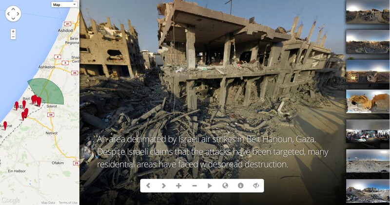
A screenshot from “The Gaza War Map,” photojournalist Lewis Whyld’s website giving 360-degree views of areas devastated in Israeli attacks.
The viewer can select and virtually stand in any of 20 sites in Gaza from Rafah in the south to Beit Hanoun in the north and see a 360-degree view of the destruction all around.
Short of being in Gaza it is an effective way to get a sense of the scale of devastation Israeli bombing has caused. Try it yourself.
UN satellite imaging
The United Nations Institute for Training and Research (UNITAR) has published a series of satellite images showing areas of Gaza before and after the Israeli bombardment. Such maps are used by international agencies to make overall damage assessments.
For instance, using satellite images, the UN estimated that as of 25 July, the Israeli bombardment had completely destroyed 700 structures and severely damaged 316 others in (a “structure” might be an individual house or an entire apartment block with a number of individual units) in the eastern Gaza City districts of Shujaiya, Tuffah and Shaaf (see the PDF below).
Gaza Crisis Atlas
UN OCHA has published another invaluable resource, the Gaza Crisis Atlas.
Viewable online, it contains numerous maps and satellite images with neighborhood-by-neighborhood information about the destruction in Gaza.


Comments
Gaza
Permalink robert then replied on
They say never again, as the bombs drop on children,men and women and asking for billions in aid and more bombs Im not sure what is worse What Germany did to the jews or what israel is doing to the Palestinians.
Heroic People
Permalink Caitlin Ni Chonaill replied on
The courageous, ingenious Palestinians will never be beaten. Modern-day heroes.
modern remote control planes; no secrets on the ground
Permalink sanda aronson replied on
The toys of my youth, "remote control" planes have progressed to being able to take video/photos. So, governments that kill journalists to keep stories secret can't keep out the photo/video machines on drones. Drones used to only mean worker bees in a hive. That one can use them for taking video film in small size machine (and coming soon to police department for "testing" in several U.S. cities) to large ones for remote control planes shooting missiles is almost more tech than I can image and scary.
I do appreciate the film footage on this blog posting. My condolences to the people who were killed, injured or made homeless by my government' support of Israeli bombing, which was not done in my name.