The Electronic Intifada 24 March 2014

A Palestinian woman watches her sheep on grazing lands on the “other” side of the route of Israel’s illegal West Bank separation wall, March 2013. Once the wall is completed, it will virtually surround al-Walaja village, and the village will have lost some 85 percent of its agricultural lands and a painful share of its cultural heritage.
Sheerin al-Araj, a prominent Palestinian activist from al-Walaja described her village this way in her TedEx Ramallah talk in 2011:
Al-Walaja is a microcosm of Palestine. It’s a window into the Palestinian people’s suffering. It’s a glimpse into the Palestinian people’s resilience, the Palestinian nation’s resilience. For me it is one of the most beautiful places on earth and believe me I have been to many places…. Among this beauty, there is madness – madness that stems from the Israeli occupation that began back in 1948. In October that year, my entire village was forced out by Zionist militias and we scattered all over the world as refugees, mainly in refugee camps in Amman, [Jordan].
Al-Walaja is a beautiful Palestinian village of around 2,000 people, located partly in the occupied West Bank’s Bethlehem governorate. It is well known for its water sources, its beautiful landscapes and agricultural terraces.
According to UNWRA, the UN agency for Palestine refugees, the village used to span more than 17,793 dunums (4,400 acres).
But after more than six decades of continuous dispossession, it stands to be reduced to around 3,000 dunums through the completion of Israel’s separation wall in the West Bank – meaning a loss of around 85 percent of its agricultural lands and a painful share of its cultural heritage.
The original village of al-Walaja used to be located a few kilometers away in today’s Jerusalem district, with its vast agricultural lands reaching into today’s Bethlehem area and occupied East Jerusalem.
In 1948, when most of historic Palestine was ethnically cleansed by Zionist militias, the residents were forced to leave.
Some 75 percent of the village land, including its built-up area, was annexed to the newly declared State of Israel, from which the villagers have been barred ever since.
While most fled to refugee camps in the region, some residents settled in caves and mud houses on village lands that lay across the 1949 armistice line (“Green Line”) hoping to return. As this hope dwindled over time, they built permanent structures and created today’s al-Walaja.
In 1967, when Israel occupied the West Bank, including East Jerusalem, and the Gaza Strip, half of the new al-Walaja (2,095 dunums) was incorporated into Israel’s unilaterally expanded and annexed “Jerusalem municipality,” although residents of this area were not granted residency rights and subsequently faced decades of fines and house demolitions.
In the next decades, more village lands were illegally annexed for the construction of the Gilo and Har Gilo settlements, as well as for the construction of a “bypass road” that is reserved for the exclusive use of settlers.
The construction of the wall, which began in 2007 in spite of an ongoing legal battle and protests, constitutes the latest chapter of the continuing history of dispossession of al-Walaja.
Once completed, it will encircle the built-up area of the village and annex most of the remaining agricultural lands to the ever-growing “Jerusalem municipality.” A single checkpoint will regulate access to the rest of the West Bank.
Experience indicates that residents will likely face arbitrary difficulties reaching their work places, schools or basic services and will effectively be denied access to their agricultural lands on the other side of the wall. Many will see no option but to leave.
I started to visit al-Walaja in 2006 for one of the first organized demonstrations against the wall and have been documenting both the villagers’ resistance and the ongoing dispossession of their lands ever since.
I witnessed the harsh repression against the villagers’ unarmed demonstrations. Old people, women and children sitting in front of the bulldozers violently dragged away by the Israeli army. Hundreds of trees uprooted. Pieces of mountains blown up. Farmers and shepherds losing their livelihoods and hope. Barbed wire and military gates erected around the village. Beautiful landscapes forever destroyed.
As the wall is about to be completed, it is urgent that we witness the ongoing struggle of the people of al-Walaja against the slow death of their beautiful village.

Absiya Jafari, who is more than 100-years-old, holds a Palestinian passport issued during the British Mandate, which governed Palestine from 1923 to 1948, belonging to her husband and herself, November 2013. The original village of al-Walaja was completely destroyed in 1948 during the Nakba – the ethnic cleansing that led to Israel’s establishment in 1948 – and all villagers were forced to leave and became refugees. Many fled to Jordan, Lebanon and the Bethlehem area. Today, 97 percent of the residents in al-Walaja are refugees.

Yasser Khalifa, 45, on his lands that are located on the other side of the route of the separation wall, November 2013. Khalifa’s family owns around 40 dunums on the other side of the wall. Once it is completed, it is unlikely that they will be granted access to these lands.

Palestinians near the remains of the house of Khader Rabah, demolished by the Israeli occupation forces on 22 March 2006. Most of the part of al-Walaja that is on today’s shrinking West Bank side was designated as Area C after the signing of the Oslo accords in 1993, granting full authority to the Israeli military. Effectively, homeowners in most of al-Walaja – those in “Area C” and those in “Jerusalem” – are required to obtain building permits from Israel for any structure built after 1967. Since these permits are practically impossible to get and Palestinians are left with no choice but to build anyway, many residents have lived through multiple demolitions of their homes and other forms of harassment.

A bulldozer uproots olive trees on the land of Ahmed Barghouth (known in the village as Abu Nidal) for the preparation of the construction of the separation wall, June 2010. The grave of the parents of Abu Nidal and 40 dunums of his lands are located on the other side of the wall’s route.

Mohammad Awadallah, 72, near his house, November 2013. His house was damaged by explosions when the Israeli army blew up parts of the mountain to enlarge the route of the separation wall and he owns two dunums on the other side of the wall. He said, “the impact of the wall is that we are now in prison and lost our land. In addition there will be a gate at the entrance of the village, which will cause the collapse of the life of the village.”
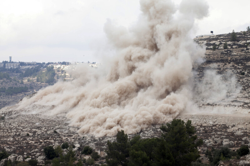
A huge cloud of dust hangs in the air following an explosion, in which the Israeli army blew up parts of the mountain to clear the route of the wall, November 2011. A series of explosions caused damage to nearby houses.
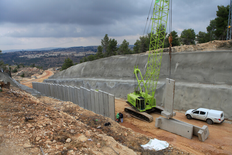
The building of the wall has had disastrous consequences on the natural environment. Hundreds of trees have been uprooted and the landscape in some places was irrevocably altered.
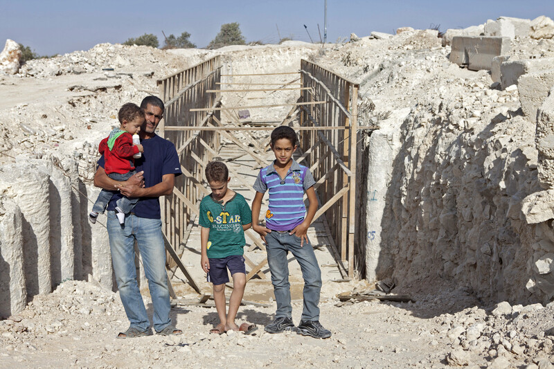
Omar Hajajlah and his three sons in front of the construction site of a tunnel built in front of his house, October 2011. The house of the family was left on the “other” side of the route of the separation wall. The tunnel will be the house’s only connection to the village and the home will be completely surrounded by an electrified, four-meter-high barrier. Hajajlah works in East Jerusalem. Since the start of the construction of the wall in front of his home, he was hospitalized twice due to heart problems. A military gate was also put in front their house, blocking the road leading to the Cremisan Monastery and the Salesian Sisters’ school, which Hajajlah’s children attend. Instead of a few minutes’ journey to school, they have to take a detour of several kilometers.
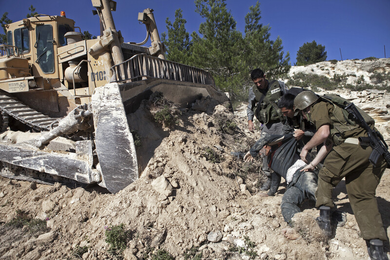
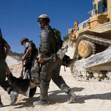
Israeli occupation forces arrest a Palestinian next to a bulldozer during a protest blocking the bulldozers that are clearing the path for the wall, April 2010.
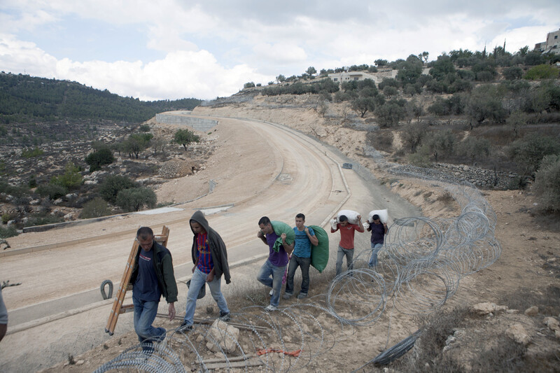
Members of the Atrash family carry equipment and olives through the mountains by the route of the wall after harvesting on their lands on the other side of the barrier, October 2012. The family owns more than four dunums in the al-Walaja valley. The family can only get to their lands by walking through the mountains and going through a gap in the wall.
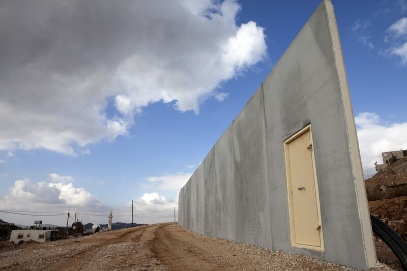
An unfinished section of the separation wall at the entrance of the village of al-Walaja, December 2010. Once the wall is completed, there will be a single checkpoint controlled by the Israeli military at the entrance of al-Walaja, turning the village into an open-air prison.

Shireen al-Araj, a prominent activist in the struggle against the wall, confronts an Israeli soldier during a protest. She said, “This is sumoud [steadfastness]. I am fighting day-to-day with my community … We are here, we are fighting and we exist. We are samidin [steadfast].” (TedEx Talk, Ramallah, 24 May 2011)
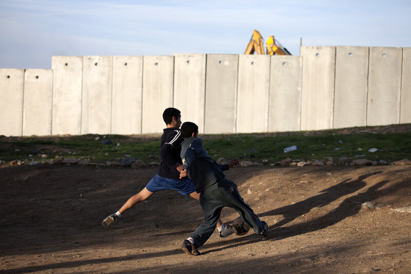
There is very little open space for the children to play. Al-Walaja has only one UNRWA school which serves students until ninth grade (14-15-years-old). Older children attend schools in Beit Jala and Bethlehem. Once the wall is completed, they will have to pass through an Israeli military checkpoint on their way to school and back.
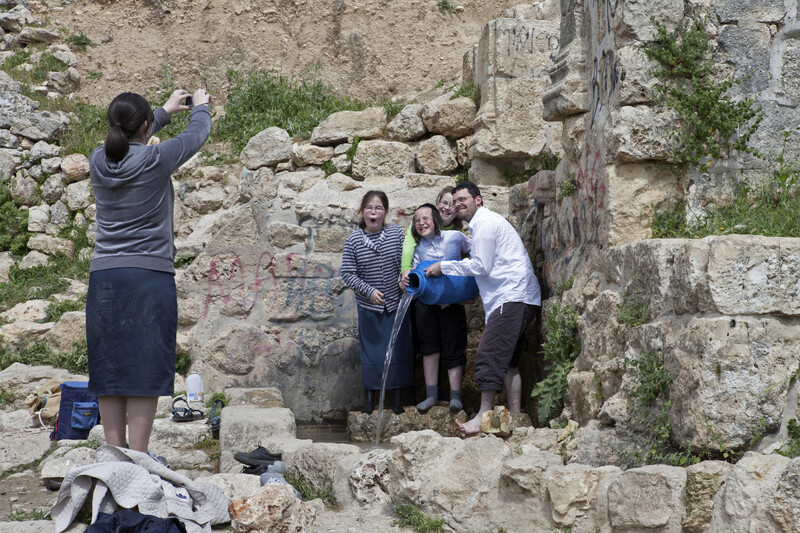
Israeli settlers often go for recreational activities to the ruins of the original village of al-Walaja that was ethnically cleansed in 1948. Only a few partially destroyed houses remain standing. The inhabitants of al-Walaja are denied access to this area. The dispossession was further entrenched by a decision in July 2013 by which about 1,200 dunums of the lands that lie between the 1949 armistice line and the wall were slated for the construction of a new Israeli national park.
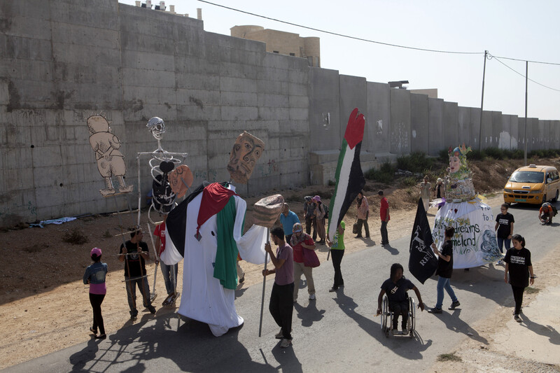
A protest march with giant puppets made in the village passes by the separation wall near the Har Gilo settlement, September 2012. Har Gilo, established during the 1970s, is built on the lands of al-Walaja and Beit Jala. All Israeli settlements in the occupied West Bank are illegal under international law.
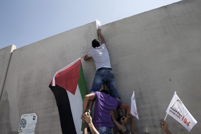
A Palestinian climbs the separation wall to raise the Palestinian flag in front of Har Gilo settlement during a demonstration, September 2011.
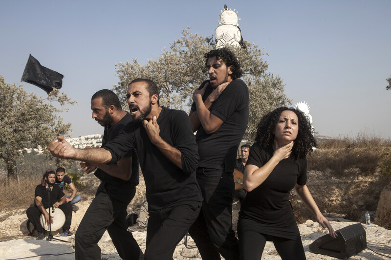
Performance by the Freedom Bus theater group based on stories by the residents of al-Walaja during an event on a mountain top that is soon to be cut off from the village by the wall, September 2012. Palestinians often use creative resistance as part of their struggle against the occupation.
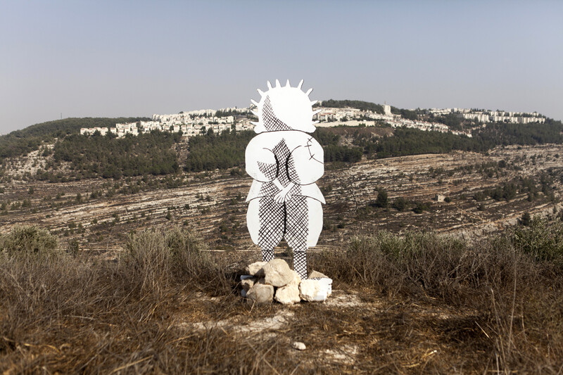
A cardboard representation of the character Handala, created by the Palestinian cartoonist Naji al-Ali, during an event protesting the building of the wall, September 2012. Handala is a symbol of Palestinian resistance and steadfastness.


