The Electronic Intifada 9 July 2004
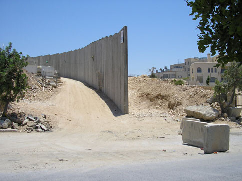
Israel’s Apartheid Wall under construction between Tantura and Beit Sahour (Photo: Arjan El Fassed)
Last summer, I spent several weeks in Beit Sahour, the West Bank town in which I’ve carried out field work since the late 1980s, observing—amongst other things—the rapacious hunger with which Israel’s “Anti-Terrorist Fence” (more commonly known as “The Wall”) consumed Palestinian lands and infrastructure, biting off roads, wells, housing projects, community centres and other supports of Palestinian life.[*] On the northern border of Beit Sahour the Wall was for the most part a bulldozed strip of between twenty and forty metres in width containing two three-metre barbed wire topped fences, a ditch, another fence equipped with electronic movement sensors, two raked sand “trace strips,” and a paved patrol road. It meandered through the countryside in what appeared to be an aimless and extravagant manner (extravagant as it costs on average US$2.27 million per kilometre), until I recognized that it ran right along the edge of the inhabited sectors of Beit Sahour and neighbouring Bethlehem and Beit Jala, gathering behind it nearly all of the vineyards, the olive groves, the orchards and other agricultural lands of the local people. [1]
The Wall, however, was not the only bit of caging being erected. Since September 2000, when the Second Intifada erupted following Ariel Sharon’s armed “visit” to Jerusalem’s Haram esh-Sharif, Bethlehem District had been ghettoised through the programmatic erection of fifty seven barriers across its roads, fifty kilometres of “Anti-Terrorist Fence,” and a tight bracket of “bypass roads” which, to the 170,000 Palestinians trapped inside, were functionally indistinguishable from the rest of the Wall. To the east of Beit Sahour the Wall linked up with the “Za’tara Bypass Road” (a militarily guarded “settlers-only road” between Jerusalem and Tequ’a which neither passes through nor allows access to or from Palestinian towns or villages). To the west the Wall sliced through residential and commercial areas of Bethlehem and Beit Jala (devastating them through its imposition of an emptied security zone stretching from the Wall between fifty and one hundred metres into Palestinian territory) before butting up against Route 60, a settlement “motorway” running from Jerusalem south to Efrat and to settlements beyond which, again, cannot be accessed by vehicle from the Bethlehem townships.
All roads out of Bethlehem district to the south had been cut, often by simply bulldozing up the roadbed and turning it into a three-metre high wall of rubble. Armoured fencing separating the extensive settlement complexes of Tequ’a, Efrat and Migdal Oz from nearby Palestinian villages was expanding into Palestinian lands at a rate exponentially related to the growth of the settlements themselves. There was only one road in and out of Bethlehem district and that, fiercely guarded at checkpoints by the Israeli Defense Force (IDF), could only be traversed by yellow-plated (i.e. Israeli-licensed) vehicles bearing soldiers, settlers, journalists, and the occasional tourist. Palestinians who wanted, or needed, to get in or out of Bethlehem District went by foot, either (if they had “permissions”), trudging through the long slow queues at the checkpoints or, if not, clambering illegally over the remains of their broken roadways so as to gain access to the busy traffic of everyday Israeli life.
That said, what I witnessed and recorded last summer in Beit Sahour was far less dramatic than what I knew was happening in other regions of the West Bank and the Gaza Strip. Qalqilyah and Tulkarem, in the north of the West Bank, were being encircled by single-gated, eight-metre high stretches of concrete wall crowned with smoked-glass windowed watchtowers and protected by ditches, patrol roads and supplementary fences. The ghettoisation of these cities was not only preventing their inhabitants from working in either Israel or the West Bank (see Bornstein 2002 for an analysis of the fostered economic dependency of Tulkarem residents on Israel before the Wall’s erection), but was also depriving those living in satellite villages of access to markets for selling their produce and labour and buying goods as well as cutting them off from basic services such as medical care and education. There, where the “sealing” was much more efficient, entry to and egress from the cities was only possible for those willing, or able, to wait in long and faltering queues for bored Israeli soldiers to interrogate them — often involving public strip-searching and other forms of humiliation — before deciding whether or not to let them, one by one, in or out.
Encystation
It seems obvious that the horrific grandiosity of the Wall’s “sealing off” of Qalqilyah and Tulkarem serves to reassure a nervous Israeli electorate inhabiting the coastal cities so near to these West Bank conurbations that the “Arabs” won’t be able to get to them. The “quieter” rhetoric with which the section of “fence” surrounding Bethlehem District speaks of Israel’s “security needs” seems more appropriate for addressing foreign diplomats, journalists, and tourists more likely to be travelling in the vicinity of Jerusalem. Differences in appearance are, however, deceptive. Beneath these diverse visual rhetorics operates a unitary logic that I call “encystation.” Encystation is the process of enclosing within a cyst (a cyst is a “sac containing morbid matter, parasitic larvae etc.; a cell containing embryo, etc” [Concise Oxford English Dictionary]) and the encirclement of Palestinian communities within the territories over which Israel — in violation of the Fourth Geneva Convention and numerous United Nations Security Council resolutions — claims sovereignty is indisputably a matter of quarantining “matter” held to put the surrounding social body at risk, as is clearly set forth on the Israeli Government’s official website: “It cannot be clearly stated that the Palestinians’ right to freedom of movement must take precedence over the right of Israelis to live.” [2]
It is unclear whether or not there is a “goal” at the end of this process. Convincing arguments can be made that the walling is meant to bring about either or both the voluntary emigration and involuntary expulsion of Palestinians. Rates of emigration in Bethlehem and elsewhere in the Occupied Territories are currently at an all-time high, and the inclusion of the right-wing Moledet (“Homeland”) party, whose platform urges “population transfer” as the solution to the problem of Palestinians, in a ruling coalition led by Ariel Sharon (who has, since the fifties, promoted the line that “Jordan is Palestine”) [3] does little to quell fears that what the Israeli historian Benny Morris recently called the “mistake” of the “non-completion of the transfer [in 1948]” (Shavit 2004) might be rectified in the not-too-distant future.
Yet, regardless of whether the ultimate motive for walling is making people leave or simply to make them invisible to the Israeli population, it is indisputable that life within Palestinian “gated communities” is being etiolated by an intentional crippling of the economy, the strangling of access to food, water, medicine, and education, and the imposition of a sense of isolation and political impotence. Palestinians, or at least those within these enclaves surrounded by Israeli settlements and highways, are certainly not treated as part of what is popularly known as “the only democratic state in the Middle East.”
Nor, for the most part, do Palestinians in the West Bank and Gaza want to be part of an Israeli state. They want their own state in the seventeen percent of Mandate Palestine left under “Arab” control (albeit by fiat of Egypt and Jordan rather than the decision of the local Palestinians) after Israel expropriated the rest in the war of 1948. Although the liberal European press has tended, since the summer of 2003, to condemn Israel’s building of the Wall, it has done so on the assumption that the Wall is intended to constitute the border between a nascent Palestinian state and a state of Israel in retreat from maximalist positions. Liberals assume the Wall should run along the “Green Line,” the internationally recognized armistice line established at the close of the 1967 war, which is one hundred and ninety miles in length. They are outraged that current government plans project a total length for the Wall of between three hundred and sixty and four hundred and thirty five miles. None of the circuitous wanderings of the existing wall takes place on the Israeli side of the Green Line, while at a number of points it bulges dramatically into the West Bank to incorporate Israeli settlements. The Wall’s “land grab” threatens to expropriate up to ten percent of the West Bank, and commentators note that this puts any idea of a Palestinian state at risk — especially given that the most fertile lands, and the largest aquifers, are within the territory being consumed by the wall.
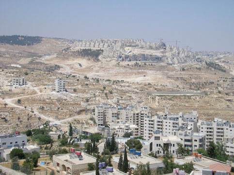
Israel’s Apartheid Wall under construction between the Israeli settlement “Har Homa” built on Jabel Abu Ghneim and Beit Sahour. Ironically the meaning of the Hebrew name of the settlement “Har Homa” is literally “Mountain of the Wall” (Photo: Arjan El Fassed)
But is the Wall meant to be a border? It is important to note, in my descriptions of Bethlehem, Qalqilyah and Tulkarem above, that the encircled towns are cut off just as much from the West Bank as from Israel; Palestinians must cross through checkpoints to access other sectors of Palestine. Numerous other towns and villages will be “enclaved” by supplementary fences built around them, while the effects of road cuttings and roadblocks (as detailed above in Bethlehem district) on countless other Palestinian conurbations do not even show up on the detailed map of the Wall the Palestine Land Development Information Systems drew up in 2003 on the basis of the Israeli Defense Force plans. [4] Also not shown on that map is the fact that the city of Jenin, a considerable distance from the projected path of the fence, is currently being walled. Meanwhile, despite the outrage expressed by “outside” critics of the Israeli state for its pushing of the Wall up to three and a half miles into the West Bank so as to incorporate Israeli settlements such as Alfe Menasha, the projected path of the “western” Wall (that taking its bearings from the Green Line) will leave ninety eight percent of West Bank settlers on the east side of the Wall. This population (which holds Israeli citizenship despite their “extra-territorial” residences) can move without hindrance along their own roads and through roadblocks designed to stop only Palestinians. Despite this freedom, long-term plans (announced by Ariel Sharon in March of 2003) envisage another wall running down the entire length of the Jordan Valley’s western rim, effectively caging the entirety of the West Bank. Towns and villages left on the outside of the walls, either to the west or to the east of the “Palestinian territories,” will be stranded in the midst of hostile territory, severed from other Palestinian communities.
Palestinian communities “inside” will be similarly quarantined insofar as walling will divide the remaining territories into three discontinuous “cantons” containing forty five to fifty percent of the West Bank’s current territory, three “depth barriers” (fully encircled domains with single entry and exit points), and at least six further fenced enclaves (see Cook 2003). It is hard to imagine the borders of a Palestinian state comprised of a series of non-contiguous Bantustans around, between and through which swarm armed settlers and the tanks, bulldozers and personnel carriers of an antagonistic foreign military.
The concept of ‘border’ has been both central to and multivalent in Israeli practice and discourse since early days of the state, as Adriana Kemp has shown in her study of the role of the border and of military border violations in the shaping of Israeli identity. She contends that
the territorialist idiom of settlement, which presented the boundary as the ultimate symbol of state sovereignty, did not take root in the Israeli mind. The army gradually initiated practices which transferred activity to the other side of the border … [so that] the breaching of the border became a symbolic practice, a genuine territorial ritual, which had the effect of both trivialising the border and instilling a sense of lordship over the territories across the lines” (Kemp 1998: 89-90, 92).
Kemp is talking of cross-border violations in the period when the West Bank was in Jordanian hands (although a favourite Israeli incursion during that period targeted the Nabatean city of Petra, well beyond the Jordan River). The “frontiers” conception of borders Kemp says characterizes Israeli attitudes towards state and sovereignty is still in play in Israeli state policies, not only towards Lebanon and Syria but also with regard to what international law declares is the illegally occupied territories of the West Bank, the Golan Heights and the Gaza Strip, where the state establishes settlements, builds roadways and other infrastructural “facts on the ground,” and maintains the citizenship of “extraterritorial” settlers.
The duality of the concept of border in operation today in the Occupied Territories is analogous to its meaning in the period Kemp discusses (1949-1957), when border crossings by the Israeli military were designed to punish Palestinian communities for allowing refugees (who, for the most part, were attempting to return to houses and properties from which they’d been forced to flee in the course of the 1948 war and subsequent “mopping up” operations) to attempt to gain access to Israel:
Crossing of the lines by the Palestinians was portrayed as a ‘gross violation of the armistice agreements’ and was called ‘infiltration’. However, when border-crossing became a habit of the Israeli army, even if unacknowledged, it was known as ‘routine security measures’ and depicted as part of the attempt to achieve ‘border discipline’ ” (Ibid. 87).
The fact that borders continue to be delineated as devices for encysting Palestinians is manifest in the contemporary operations of the “Border Police,” a “police” unit under the command of the military which is supposed to patrol borders as well as ports and airports. In practice, the Border Police go into operation wherever Palestinians confront Israelis in what the authorities perceive as a political manner. Thus, when Sharon’s “visit” to the Haram esh-Sharif sparked demonstrations in “Arab” towns and “mixed” cities within Israel’s 1949 borders, it was the Border Police that was sent into the Galilee to suppress these, at the cost of thirteen “Israeli Arabs” shot dead. Borders, whether those drawn by the Wall or those of “Closed Military Areas” which any officer can declare at whim, pertain to Palestinians, and are erected wherever and whenever a Palestinian is seen to impinge upon or question Israeli sovereignty over “the land.”
If borders for Israelis exist in large part for the “symbolic practice” of breaching them, as Kemp suggests, how then does one discern the limits of “the land of Israel”? This question concerns not only the legal rights of settlers to benefits accruing from Israeli citizenship, which are refused their “Arab neighbours” in the Occupied Territories. It also has “extraterritorial” implications and applications. Israel’s “Law of Return 5710-1950” promises that “every Jew has the right to come to this country as an oleh [an immigrant]” (http://www.mfa.gov.il/mfa/go.asp?MFAH00kp0), which in practice has come to mean that any person claiming to be a Jew, either by descent or conversion, is granted automatic citizenship as well as guaranteed housing, full tuition for language and university education and significant discounts on cars, appliances and other aids to settlement ( http://www.us-israel.org/jsource/Judaism/whojew1.html).
Beyond, however, easing aliyah [immigration], the Law of Return implies that, by virtue of being Jewish, Jews outside of Israel are in effect always already Israeli citizens (a parallel instance from Former Yugoslavia is analysed in Dimitrijevic 1993: 50-56). In line with the effective extension of Israeli state sovereignty entailed by this guarantee of automatic citizenship, Israel has, in the past few years, intervened in cases in which Jews were on trial for crimes committed outside of Israel, as though these were cases in which its own citizens were being tried by a foreign state. It has also, in Iran, Iraq and Ethiopia, organised massive “rescue missions” taking Jewish citizens of other countries out of those countries and “resettling” them in Israel. [5] If Israeli sovereignty is extensible to anywhere Jews exist, then there are in effect no borders.
Certainly, in terms of its violation of international borders in defence of its self-ascertained interests, Israel acts as though they do not exist. In several instances, dating from the earliest days of the state until the present, Israel has ignored extradition processes and kidnapped persons it deemed criminals from foreign states. Strikes against and invasions of Lebanese territory are virtually routine, and it is worth noting that Israel has laid claim to the following violations of other states’ sovereignty as expressions of its right of self defense: the 7 June 1981 bombing of the Osiraq nuclear power plant in Iraq; the April 1988 assassination in Tunis of Abu Jihad in a substantial military operation; and the bombing on 5 October 2003 of Ein Saheb refugee camp northwest of Damascus. If within Israel and the Occupied Territories every Palestinian has a border inscribed around him or her, in the global context Israeli sovereignty is extendable to anywhere Israeli-defined “Jewish” interests can be discerned.

This satellite image of Qalqilya and the wall surrounding the city was taken on 7 June 2003. (Image: Space Imaging Eurasia)
I return, in closing, to the concept of “encystation.” Like the concept of “border” in Israeli discourse, “cyst” also has a double meaning; it is both a closed sac in which morbid matter is quarantined so as to protect the surrounding body, and a “cell containing an embryo” which provides a defensive membrane within which that foetal entity can develop until it has grown sufficiently strong to emerge into the world outside. It is in the latter sense that Israel, as a homeland for the Jewish people, was conceptualised by Herzl and the late nineteenth century Zionist pioneers who saw the land as a place distant from Europe and its anti-Semitism where Jews, weakened by centuries of discrimination, could shelter while developing into what Herzl termed “real men” (Complete Diaries I, 19 cited in Kornberg 1993: 166; see also Bowman 2002: 456-463). Unsurprisingly, as a protected space within which a people could shelter and grow strong without encountering debilitating competition and challenges, Israel’s founders envisaged not only the need for strong defenses against an “outside” but also means for ensuring that any internal challenge to the development of sovereignty would be contained, expelled or destroyed (this position is elaborated in Ze’ev Jabotinsky’s 1923 “Iron Wall”; see Shlaim 2000: 11-16).
Modern day Israel, which — with its massive army, its nuclear capabilities, and its high technology economy — certainly has entered forcefully into the global community of mature states, nonetheless still wants to pose itself as a protective womb for a foetal people. As a result, it encysts non-Jewish populations within the territory over which it imposes de facto sovereignty, refusing them even the semblance of self-determination (see Kimmerling 2003). It simultaneously extends its protective wall outwards so as to encompass and protect all the members of a globally distributed ethno-religious population that it views as its “concern.” Like the United States, which, with the demise of the Soviet Union, is able to celebrate its power to defend its citizens and its interests everywhere, Israel has, with its victories over the antagonisms against which it established itself, become unrestrained in its will to sovereign power both within and beyond its borders.
Related Links
Endnotes
* See Glenn Bowman’s photographs of the Bethlehem/Beit Sahour region. [Powerpoint file]
1. According to the Applied Research Institute-Jerusalem the walling of the Bethlehem district has resulted in the alienation of seventy square kilometres of the total six hundred and eight square kilometres, which make up the district http://www.poica.org/casestudies/Checkpoint%2023-02-04/index.htm
2. Ministry of Foreign Affairs, The Israeli Government’s Official Website: http://securityfence.mfa.gov.il
3. See Shlaim 2000: 477 and passim.
4. See http://www.pengon.org-wall-newmaps-poster.pdf
5. This settlement policy has even included the conversion of Incan Indians from the mountains of Peru and the subsequent importation of these newly minted Jews into West Bank settlements. See Goodman 2002.
Bibliography
Bornstein, Avram. 2002. Crossing the Green Line between the West Bank and Israel. (The Ethnography of Political Violence). Philadelphia: University of Pennsylvania Press.
Bowman, Glenn. 2002. “ ‘Migrant Labour’: Constructing Homeland in the Exilic Imagination” in Anthropological Theory. II: 4. pp. 447-468.
Cook, Catherine. “Final Status in the Shape of a Wall”, Middle East Research Information Project (MERIP), 3 September 2003, http://www.merip.org/mero/mero090303.html.
Dimitrijevic, Vojin. 1993. “Ethnonationalism and the constitutions: the apotheosis of the nation state” in Journal of Area Studies. 3. pp. 50-56.
Goodman, Hirsh. “ZAP! You’re Jewish!”, Editorial, Jerusalem Report, August 2002, p. 48.
Kemp Adriana. 1998. “From Politics of Location to Politics of Signification: The Construction of Political Territory in Israel’s Early Years”, Journal of Area Studies. 12. pp. 74-101.
Kimmerling, Baruch. 2003. Politicide: Ariel Sharon’s War Against the Palestinians. London: Verso.
Kornberg, Jacques. 1993. Theodor Herzl: From Assimilation to Zionism. (Jewish Literature and Culture). Bloomington: Indiana University Press.
Shavit, Ari. “Survival of the Fittest” [interview with Benny Morris], Haaretz (Friday Magazine), 9 January 2004 (see http://www.logosjournal.com/morris.pdf .
Shlaim, Avi. 2000. The Iron Wall: Israel and the Arab World. London: Allen Lane.
Glenn Bowman is senior lecturer in the Department of Anthropology at the University of Kent, Canterbury, U.K. This paper was originally published in Social Analysis: the International Journal of Cultural and Social Practice. Volume 48, No. 1, Spring 2004, pp. 150-155. Professor Bowman may be reached at: glb@kent.ac.uk

