The Electronic Intifada 28 January 2015
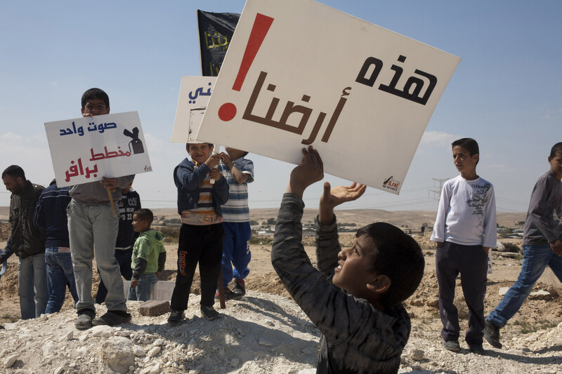
A boy displays a sign that reads “This is our land!” during a vigil to mark Land Day in the unrecognized Bedouin village of Wadi al-Naam in present-day Israel, 30 March 2012. Bedouins in the southern Naqab region have resisted decades of ongoing, forced displacement by Israeli authorities.
ActiveStillsAn interesting plan for dividing Israel into provinces was published a few months ago by Haaretz. It suggested a remedy for the fragmentation of Israeli society and its failure to create a melting pot for Jews immigrating to Palestine.
In this article I provide a critique of the pros and cons of this plan and offer an alternative. The scheme, laid out by Carlo Strenger and Judd Yadid in a 7 October 2014 article entitled “How Cantonization can save Israel,” admits that Israel’s leaders failed “to impose a monolithic ideological and cultural hegemony on the country’s population.” The Ultra-Orthodox Jews, for example, were not “converted into card-carrying Zionists.” Tel Aviv residents will not “put up with marriage laws” with a foreign and invasive nature.
Strenger and Yadid find that the answer to “the country’s myriad identities” is to quarantine “the feuding peoples of Israel” into several different provinces with different regional powers with which they would exercise the life they are used to, according to their cultural and religious values. Or perhaps, more practically, they could continue to live as they did in their mother countries before they emigrated to Palestine, ranging from ghettos in Eastern Europe to affluent neighborhoods in London.
If this looks like a stark admission of the failure of “in-gathering of the exiles,” Israel’s President Reuven Rivlin was not mincing words when he declared at a conference on racism and hatred in Jerusalem last October that “Israel is a sick society with an illness that demands treatment.”
The lack of homogeneity in Israel is not surprising; the Jewish immigrants came to Palestine from 110 countries and they spoke more than eighty languages and dialects. Many of them continued their traditional ways, even though they learned modern Hebrew and their youth joined the army. The army was supposed to be the perfect melting pot for forging unity among immigrants against a common enemy, the Arabs, among whom they found themselves when they settled in Palestine. The conflicting backgrounds and diverse origins of the Israelis have been the subject of many studies. There are dozens of books, almost all by Jewish authors, on the fragmentation of the Israeli society, the failure of the melting pot, the ideological and economic bankruptcy of the kibbutz, the crises of “Israeli” identity, the founding myths of Israel, the invention of the Jewish people and the “Land of Israel,” the meaning of “post-Zionism,” the military character of Israel, the exploitation of the Holocaust and the mythical narrative of Israel’s birth and the attending denial of the Nakba – the 1948 ethnic cleansing of the Palestinians.[1]
Dividing Israel to save it
This cantonization scheme is probably the first time that a Zionist proposal is made to separate the diverse groups geographically and legally at the “province” level. It probably aspires to resemble the Canadian provincial system with the obvious difference that the proposed Israeli provinces are tiny slivers of land, more like a British borough than the vast regions of Canada. Even so, the scheme represents optimism that present-day Israel, excluding the West Bank and Gaza, but including occupied East Jerusalem and Syria’s Golan Heights, can be divided into twelve provinces (see Map 1 below).
There would, for instance, be an “Orthodox religious province” of “Yehuda” stretching north from Jerusalem to “incorporate the majority of the country’s religious Jews” and including more than 1.6 million people on about 1,060 square kilometers of land. And there would be a province called “Aviv” covering 220 square kilometers and encompassing 1.2 million people. It would include Tel Aviv and would thus “empower the heart of secular Israeldom to cement its distinct value set, giving liberal Israel -- both nationally and internationally -- a far louder voice and stronger brand than just one city of 400,000 people.”
Only two of the provinces, “Jalila” in the north and “Badiya” in the south, would have predominantly or exclusively Arab populations. But given the diversity in Israel, there would need to be many times more than twelve provinces for full homogeneity to prevail in each one. Nevertheless, the province scheme, designed to advance Zionist goals, is interesting in that it proposes a novel practical solution that is worthy of close study, especially since it emanates from Israel’s leading “liberal” publication.
I shall examine the proposed scheme and see that its aim is to further Zionist policies of racism and apartheid. In fact, it would not produce homogeneity among Jews and, more so, will be far away from providing a peaceful or permanent solution in historic Palestine. I will also propose an amendment to this province scheme that might make it more viable.
Jewish population is highly concentrated
For the purposes of this critique, we will take Israel’s area according to its 46 natural regions (there are 50 such “natural regions” in Israel’s administrative scheme and I have omitted the occupied Syrian Golan Heights included in the Strenger-Yadid scheme, and the occupied West Bank and Gaza Strip).
The population numbers in the cantonization plan are taken from Israel’s Central Bureau of Statistics published in 2012 and pertaining to 2011. To standardize the figures in the scheme and in my critique I have used population figures from mid–2008. Due to different years of reference and small digitization errors from the rough Haaretz map outlining the proposed twelve provinces, my approximation leaves some small differences but they do not change the character of the critique or its conclusions. As noted, the scheme proposes the “Yehuda” province of Jerusalem and areas northwest to be the Orthodox province or synagogue country. The Tel Aviv (“Aviv”) province is the liberal province or nightclub county.
In these two would-be provinces live about 2,465,000 Jews and 277,000 Palestinians. The figures are misleading on two counts. First, the stated Palestinian population is mostly in East Jerusalem which was occupied in 1967.
There are almost no other Palestinians there because 127 Palestinian villages in this area were ethnically cleansed in 1948. Second, the Jews would be much more numerous than stated in Aviv province if this province is extended to the east up to the Ultra-Orthodox town of Bet Shemesh and extended south to the port of Isdud (Ashdod), thus reducing both Yehuda and Nitzan provinces. In the extended Aviv province there would be 3.5 million Jews, or 65 percent of all Jews, which is an ideal location for a Jewish canton.
This redistribution makes sense. The enlarged Aviv province will then correspond to the area of Jewish settlements in British Mandate era Palestine, namely the western and northern part of Jaffa district.
Putting Palestinians in a ghetto
It is in Galilee where the Zionist cantonization scheme bares its true intention. Almost one third of a million Palestinians are to be confined in a ghetto called Jalila province, an area of 400 square kilometers, with a density of 825 persons per square kilometer.
In Jezreel province, 200,000 Jews are allocated an area of 1,110 square kilometers (a density of 180 persons per square kilometer) while the Palestinians in this province (80,000) would remain marginalized as second class citizens.
Similarly, in Naftali province (an area of 1,413 square kilometres), also considered Jewish, the Palestinians there are in fact almost equal in number to the Jews (220,000 to 260,000). In these four Galilee provinces, a total area of 3,300 square kilometres within Israel, the Palestinians are 640,000 and the Jews are less than half the total population at 540,000. (If you subtract Tiberias or Kinneret province the same conclusion applies.) Yet the scheme offers twelve percent of the area, a ghetto of 400 square kilometers, for 450,000 Palestinians at a density of 1,125 persons per square kilometer. This is six times the density of the Jews.
The remaining area of the four Galilee provinces (2,900 square kilometers) are designated for 540,000 Jews at a density of 186 persons per square kilometer. The Palestinians outside Jalila, about half the total population in the four provinces, would live in Jewish-designated provinces and would be treated as a minority who had no say in the affairs of their region. The owners of the land become ghetto dwellers and the settlers become the owners of the land.
In short, this plan pursues the unchanged Zionist goal of gaining the maximum amount of land with the minimum number of Palestinians, while disguising it as an exercise in unleashing diversity and pluralism.
"Planner for ethnic cleansing"
Map 1 shows the proposed provinces with total population in thousands, according to my calculations, marked on a pie chart where blue indicates Jewish population and pink indicates Palestinians. While the small area of Jalila province is fully Palestinian, incorporating 28 villages, the scheme ignores 160 Palestinian villages spreading far and wide beyond Jalila, shown here in black dots.

Map 1: Proposed division of present-day Israel into ten Jewish and two Arab provinces, showing total Jewish and Arab populations.
This is an attempt to revive the infamous Koenig Plan of April 1976, authored by senior Israeli interior ministry official Yisrael Koenig. It aimed at reducing the number, presence and influence of Palestinians in Galilee. The threat posed by the Koenig Plan led the Palestinians to counter action; they inaugurated Land Day, marked on 30 March every year since to emphasize their roots in their land. This movement is now much stronger and will not easily accept marginalization by the Israeli colonial regime.
Carmel province on the coastal plain, also seen on the same map, is designed to drown the large Palestinian presence in the Little Triangle with a population of 350,000 in 55 villages among one million Jews.[2]
This is the population that Israel’s foreign minister, the racist Avigdor Lieberman, an immigrant from Moldova and leader of the right-wing Yisrael Beiteinu, wants to expel from their homeland under the guise of a land swap. Gideon Biger, a Russian and a political geographer at Tel Aviv University, is his planner for ethnic cleansing. The junior author of the scheme, Judd Yadid, South African-born and Australia-raised, works at Tel Aviv University, where he wrote his master’s thesis under Biger.
Palestinians in this province are particularly worrying for the Israelis because of their stubborn defense of the holy sites in Jerusalem under the leadership of Sheikh Raed Salah, leader of the northern branch of the Islamic Movement.
Hence the intent of those like Lieberman who want eliminate them using a ruse: annexing their small territory to the West Bank in return for annexing to Israel bigger settlement blocs in the West Bank. Both territories on either side of the Armistice Line of 1949 -- the boundary between Israel and the West Bank -- are not legally owned by Israel and Israel has no authority to swap them.
Targeting Bedouins
The Southern District of present-day Israel is divided into eleven natural regions with a total area of 14,231 square kilometers or seventy percent of Israel’s area. In this district, about 900,000 Jews live, but of those Jews 83 percent live in four originally Palestinian towns each with more than 100,000 residents -- Isdud (Ashdod), al-Majdal (Ashkelon), Beir al-Sabe (Beer Sheba) and Iraq Manshiya (Qiryat Gat) -- and seven small, poor “development towns.” Jews living in these towns are Mizrahi Jews -- of predominantly Arab origin -- with a sprinkling of Russian immigrants, especially in Beir al-Sabe. The remaining Jews, 17 percent, are scattered in 212 “kibbutz” and “moshav” agricultural settlements with an average population of 700 persons each and a density of only ten persons per square kilometer. Jews living there are predominantly Ashkenazim -- European Jews -- the rulers and old elite of the country, who conquered the south in 1948 and ethnically cleansed its population. The cantonization scheme divides the Southern District among several provinces: Shimon, Badiya, Halutza (Khalasah), Arava (Wadi Araba) and three quarters (1,051 out of 1,430 square kilometers) of Nitzan province.
Together with the 900,000 Jews living in the Southern District, more than 200,000 Palestinians live there in 55 villages, half of them not recognized by Israel and denied all services. The cantonization scheme allocates 600 square kilometers for them in Badiya province at a density of 380 persons per square kilometer, or about forty times the density of settlers in the region. This is worse than the second ethnic cleansing which took place after the Nakba of 1948, when in 1950 the remaining Palestinians in the area were herded in a racist reserve called the siyag (fence) with an area of about 1,100 square kilometers, or nine percent of the Beer Sheba (Beir al-Sabe) district of Mandatory Palestine in which they lived before 1948.
The scheme only allows 30 villages of the total 55 to be included in Badiya province. As shown in the map, 25 Palestinian villages are situated outside Badiya province and its population would be ethnically cleansed for the third time and relocated to the new reduced siyag. The seizure and confiscation of Beer Sheba land has been going on since the ethnic cleansing of 1948. The present-day case of al-Araqib village is very well known. It has been fighting for its survival as it was demolished and rebuilt more than fifty times and counting.
The owners of the land submitted to Israeli courts documents showing their ownership and land cultivation through the British Mandate of Palestine and during four centuries of Ottoman rule. The court ruled against them. It derived its verdict from a testimony of its “expert,” Professor Ruth Kark of the Hebrew University, who stated, as reported to me by another expert witness, Professor Oren Yiftachel, that “there are no Palestinians there. Only shepherds who came from Saudi Arabia with their flock for grazing and then left.” Again, the scheme is a resurrection of the racist Prawer Plan to remove tens of thousands of Palestinian Bedouins in the area from their land, which was defeated temporarily in January 2014 due to local and worldwide protest, but which will very likely be repackaged and introduced again in new garb.
Maintaining racism and apartheid
In summary, this Zionist cantonization scheme would, if implemented, allow 99 percent of Jews to live in ten Jewish provinces which account for 95 percent of Israel’s area where they can enact their own regional laws in education, health, religion, culture, language and the like. With them would live 58 percent (835,000) of Palestinian citizens of Israel under purely Jewish laws without any influence on their own affairs.
Only 42 percent of Palestinians (600,000) would live in Palestinian areas (five percent of Israel’s area), where they could run their own local affairs, with fewer than one percent of Jews.
In other words, the majority of Palestinians in Israel today would remain under the shadow of Jewish rule even for their normal civil rights. Palestinians who are twenty percent of the citizenry in Israel are to be incarcerated in two percent of Israel in Galilee and three percent in the south.
The cantonization scheme therefore fails to achieve its stated objective: to diffuse the animosity between the various components of Jewish society in Israel hailing from a hundred different backgrounds. Moreover it will further marginalize the Palestinian citizens and strengthen Israeli policies of racism and apartheid. It will arrest their development and confine them to ghettos. Deprived of their agricultural land, financial support and democratic laws, they will be reduced to cheap labor in Israeli factories.
The plan is another attempt of many to partition Palestine. Such schemes progressively swallowed up Palestinian territory in favor of Jewish immigrants, starting with the Royal Commission of 1937 to the UN-endorsed partition plan of 1947 on which Israel’s legitimacy hangs by a thread.
It is worth noting the Galilee, most of the Southern District and all the region west of Jerusalem (“Yehuda province”) are part of the area allocated to the Arab state in the UN partition plan. In this context, the 1993 Oslo accords are the latest formal attempt to make the occupier the owner of the land.
Coming at a time when the occupied West Bank has effectively been converted into several hundred cantons where Palestinians are confined by checkpoints and walls, while 650,000 Israeli settlers, many of them armed, control two thirds of it, it is clear that the cantonization plan would be the last step in the complete destruction of Palestine.
The inevitable result would be to intensify the Palestinian struggle for freedom and against Israeli policies of racism and apartheid.
Treating Palestinian property as "booty"
The scheme is of course a Zionist project. It violates international law, not only in reducing Palestinians remaining in their homeland to life in ghettos but it covers Palestinian territory which Israel illegally annexed and occupied beyond the Armistice Line of 1949. It incorporates Syria’s Golan Heights, which Israel occupied in 1967 and illegally annexed in 1981, as well as areas of Palestine acquired and/or occupied in violation of UN and Security Council resolutions and the armistice agreements of 1949.[3]
The recognition of Israel by some countries, mostly western, is mainly a de facto recognition. Inside historic Palestine, Israel’s area is delineated by the armistice line of 1949. Article II of the armistice agreement clearly states that the armistice line has no legal value; it does not grant or deny any rights or claims by either party on either sides of the line. This principle is still valid today. Israel therefore has no recognized borders.
Further, assuming Israel’s sovereignty is recognized by some countries, this does not mean that the land or property under its control are legally owned by Israel. Private ownership has a sanctity which is not diminished by occupation or passage of time. This is particularly applicable to the land and property of Palestinian refugees who were the victims of Israel’s ethnic cleansing.
Jewish ownership of land in Palestine under the British Mandate was 1,429 square kilometers, that is five percent of historic Palestine or seven percent of present-day Israel.[4] The rest is Palestinian property. The cantonization scheme deals with this confiscated Palestinian property (93 percent of Israel) as if it were Jewish owned. This violation of international law is ignored by the cantonization scheme. It deals with the land as if it was booty or war spoils to be divided among Jewish immigrants to Palestine.
Could cantonization work?
There can be no peace without the restoration of the property to its rightful owners. The right of return must be implemented. The Palestinian refugees living homeless today are more than 6.5 million.[5]
| Proposed Province | Population Mid–2008 | Jews | Palestinians in Israel | Palestinian Refugees | Net Area km2 |
|---|---|---|---|---|---|
| Naftali | 402,400 | 261,300 | 221,000 | 672,000 | 1,413 |
| Kinneret | 83,600 | 63,600 | 6,000 | 182,000 | 351 |
| Jezreel | 226,700 | 208,000 | 81,000 | 325,000 | 1,101 |
| Jalila | 448,500 | 9,000 | 332,000 | 87,000 | 401 |
| Carmel | 1,337,200 | 1,025,000 | 348,000 | 1,077,000 | 1,368 |
| Aviv | 1,159,500 | 1,320,000 | 12,000 | 933,000 | 220 |
| Yehuda | 1,568,900 | 1,144,000 | 265,000 | 1,164,000 | 1,059 |
| Nitzan | 1,093,000 | 1,016,000 | 30,000 | 1,300,000 | 1,314 |
| Shimon | 340,000 | 356,000 | 65,000 | 642,000 | 2,614 |
| Halutza | 43,300 | 51,000 | 4,000 | 142,000 | 4,716 |
| Arava | 52,700 | 57,000 | - | 27,000 | 5,258 |
| Badiya | 228,000 | - | 110,000 | 35,000 | 658 |
| Total | 6,983,800 | 5,510,900 | 1,474,000 | 6,586,000 | 20,473 |
Table 1 shows the population numbers for the putative provinces reduced to mid–2008 in the following four columns: total present population, Jews, remaining Palestinians in Israel and the Palestinian refugees registered with UNRWA and those who are not registered.[6]
It also shows the net area of provinces within the international boundary of historic Palestine (excluding the Golan Heights) but including, for the purposes of this critique, Israel’s transgressions over the Armistice Line since 1949, in order to correspond to Israel’s natural regions.
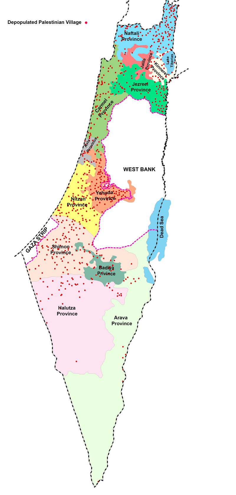
Map 2: Depopulated villages (shown as red dots) in relation to proposed division of present-day Israel into ten Jewish and two Arab provinces.
Just looking at Map 2, showing 560 depopulated villages (red dots) spread all over the country, makes the Zionist division in the scheme to twelve provinces (only two are Palestinian), an exercise in absurdity.
Palestinian refugees can actually return to their homes without much dislocation to existing Jewish populations. Extensive studies have been made to prove that this is feasible.[7] Contrary to Israeli contentions, a recent study showed that the lands of 249 villages contain no Jews today and the lands of 272 other villages contain very few Jews (mostly kibbutzniks). That leaves only three areas of Jewish concentration which can be classified as “cantons” with Jewish regional powers: the Tel Aviv metropolis, Greater Haifa and West Jerusalem. Jerusalem needs special treatment to affirm the status quo of religious sites and sanctity of private property according to UN resolutions, now violated.
Blocs of kibbutzim in the coastal plain between Jaffa and Haifa and along Marj ibn Amer (the Esdraleon Valley) may form a porous continuity with appropriate regional powers. A detailed scheme is under preparation.
There has in recent years been a revival of interest in a one-state solution in all of historic Palestine as the only practical and legal way to absorb Jewish immigrants among the native inhabitants of the country.
Whatever the ultimate solution may be, the fact remains that every person must have the free choice to return to his home or land and live in freedom under the rule of law. Colonialism, racism and apartheid have no place in our world today and must be irrevocably abolished. The Palestinian people today are twelve million, two-thirds of whom are refugees and their direct descendants, expelled from their homes in what is today Israel. Half of the Palestinians still live on Palestine’s soil. The rest are in a ring around in it, with the exception of about one million living further afield. If there is any lesson to be learnt in the last seven decades, it is that no peace can ever prevail in the region without the return of the refugees to their homes.
That, and only that, should be the subject of concern, study and implementation.
Salman Abu Sitta is founder and president of the Palestine Land Society (plands.org). He has authored numerous papers and studies on the rights of Palestinian refugees as well as five books, including Atlas of Palestine 1917-1966 and The Return Journey.
Notes
-
(Examples include The Invention of the Jewish People (Verso, 2009), The Invention of the Land of Israel (Verso, 2012) and other books by the same author, Shlomo Sand; Myths in Israeli Culture by Nurith Gertz (Vallentine Mitchell, 2000); Israel’s Changing Society by Calvin Goldscheider (Westview, 2001); Being Israeli by Gershon Shafir and Yoav Peled (Cambridge University Press, 2002); Jewish State or Israeli Nation? by Boas Evron (Indiana University Press, 1995); and The Invention and Decline of Israeliness by Baruch Kimmerling (University of California Press, 2001). ↩
-
The Little Triangle is the area annexed by Israel in the spring of 1949 by an ultimatum of imminent attack to take over the West Bank. King Abdullah I of Jordan yielded and ceded the triangle. In October 1956 Israel committed a massacre at Kafr Qasim in an attempt to force the population to flee. ↩
-
These include: the Latrun enclave in the “No-Mans-Land,” which is 48.8 square kilometers large and part of the West Bank; the dried up area of the Dead Sea (208.26 square kilometers); 200 square kilometers chopped off Gaza; and East Jerusalem and its villages (the area annexed by Israel and incorporated into the municipality of Jerusalem after 1967 is some 70 square kilometers. The area of the pre–1967 Jordanian controlled part of the Jerusalem municipality is 6.4 square kilometers). Thus the area included in the cantonization scheme (21,440 square kilometers) exceeds the land area occupied by Israel according to the 1949 armistice agreements. See Map 3.9 (page 98) and Table 4.10 (page 136) in Salman Abu Sitta, Atlas of Palestine 1917–1966 (Palestine Land Society, 2010). ↩
-
The UN upholds the validity of refugees’ property and calls on Israel to record it and pay the proceeds from its utilization until their return. See for example UN resolution A/C.4/68/L.15 of 8 November 2013. ↩
-
See: Village Statistics (Jerusalem: Government Printer, 1945); and Sami Hadawi, Village Statistics 1945, A Classification of Land and Area Ownership in Palestine, With Explanatory Notes, Facts and Figures No.34 (Beirut: PLO Research Center, September 1970). ↩
-
Figures for mid–2008 are: Registered refugees with the UN agency UNRWA are 4,400,000 and unregistered refugees are 2,150,000. See Salman Abu Sitta, Atlas of Palestine 1917–1966, (Palestine Land Society, 2010). ↩
-
Salman Abu-Sitta, “The Feasibility of the Right of Return in The Palestinian Exodus” in The Palestinian Exodus 1948–1998 edited by Ghada Karmi and Eugene Cotran (Ithaca Press, 1999); From Refugees to Citizens at Home: The End of the Palestinian-Israeli Conflict, (Palestine Land Society and The Palestinian Return Centre, London ,2001); “The Geographic and Demographic Imperatives of the Palestinian Refugees’ Return,” in The Failure of the Two State Solution, edited by Hani Faris (IB Tauris, 2013). ↩
Tags
- partition
- demography
- cantonization
- Carlo Strenger
- Judd Yadid
- Gideon Biger
- kibbutz
- bedouins
- unrecognized villages
- Galilee
- ethnic cleansing
- Yisrael Koenig
- Avigdor Lieberman
- transfer
- Raed Salah
- racism
- apartheid
- zionism
- right of return
- Palestinian Refugees
- Ruth Kark
- Oren Yiftachel
- siyag
- Palestinian citizens of Israel
- Oslo accords
- Nakba

Comments
cantonisation
Permalink Tess replied on
This excellent work of Salman Abu Sitta shows clearly that the proposition would benefit the zionists and only the zionists while keeping the Palestinian people forever in submission (no change there)
The only solution is for the world community to unite in cutting off all financial aid ,all cooperation in whatever form and in isolating completely the racist apartheid israeli state.and relegating it to within the 1948 borders.
That the cutting off of all aid in any form whatsoever should be permanent.
The Israeli state should be forced to compensate for all the deaths and destruction that they have rained on the Palestinian people for the last 66 years.
That the cutting off of all aid in any form whatsoever should be permanent goes without saying .
In order to protect the Palestinian people a new peacekeeping force, drawn from and established by all the nations that support the right of the Palestinians to rule their own country in peace, should be posted all along their borders.
Israel has only been able to abuse and disposses the Palestinian people for the last 66 years because of the cowardice of the western powers, the incapacity, double standards and all too often lack of will of the UN to bring Israel to task.
It's long past time for justice. Nowhere in the world can there ever be peace without justice .
my personality
Permalink gideon biger replied on
I am not a Russian Jew but a Palestinian Jew, now Israeli Jew. I was born in 1945 in Jerusalem, and has a birth certificat issued be Government of Palestine. My father was also born in Jerusalem, under the Ottoman regime, as well as his father.
Next time please check befor wrtting