International Solidarity Movement 7 April 2003
International Solidarity Movement activist Brian Avery was shot in the face with heavy machine gun fire in Jenin on 5 April 2003 by Israeli troops in an armored personnel carrier. Tobias Karlsson, International Solidarity Movement coordinator for the Jenin area, offered the following annotated map giving more information about the incident, thus highlighting the incredibility of the Israeli army’s claim that the shooting was a “crossfire”-type accident.
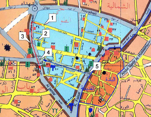
Above: Annotated map of the center of Jenin showing various points of interest. Explanation below. (Courtesy: ISM)
1. Initial position of Israeli Armored Personnel Carriers (APCs)
The first bursts of gunfire we heard originated from this approximate position at around 6:20PM.
2. Location of our apartment
From here Brian and Tobias heard the firing from the APCs. The APCs were not visible to us, we could only hear the sound of their engines and their machine guns. This is the very last burst of gunfire we heard until they shot at us ten minutes later, at around 6:30PM.
3. The approximate position of the first APC when it opened fire at us
At this point we have been visible to them for at least 15 seconds, and they have clearly identified us as international observers. They never stopped. 15-25 rounds were fired from the heavy caliber mounted machinegun while the APC was still moving towards us.
4. Position of Brian and Tobias
We were standing still, with our hands in the air, lit up by both the last daylight and electric street lights. Brian was wearing a florescent red vest with reflective decals. There were no other people out on the streets due to the curfew. Nothing was posing any kind of threat to the soldiers, inside armored vehicles. The distance between us and them at this point was approximately 50 meters.
5. Scene of clashes between armored vehicles and children throwing stones earlier in the day
Four internationals had been monitoring these clashes during the day. However, the area had been calm for over one hour before the incident in which Brian was injured. The four internationals were on their way to join Brian and Tobias, walking the route marked in blue on the map. At the time that the APC opened fire at us, they had just arrived to the scene.
Route marked in red
The route of the APCs. They drove slowly at around 15 kph. This speed was maintained throughout the whole incident. They did not stop to make sure that the shots they fired were aimed in a controlled direction. After Brian was shot they continued driving as if nothing had happened. They made no effort to investigate his condition or to provide any assistance.
Tobias Karlsson
ISM-Coordinator
Jenin area
+972 (0)57-836527
+972 (0)67-437690
Note: A print resolution version of the above map may be downloaded from http://electronicIntifada.net/maps/incidents/brianaverymap150dpi.jpg