Lobby Watch 11 March 2016
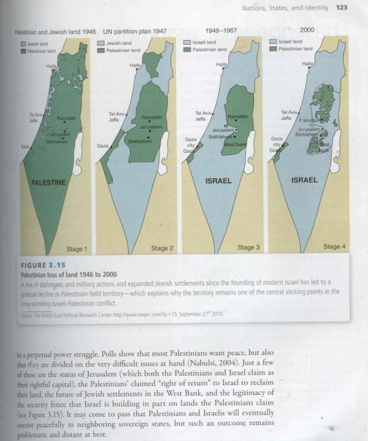
An image published by Elder of Ziyon from the textbook Global Politics, as part of the anti-Palestinian blogger’s successful campaign to pressure McGraw Hill over maps depicting land loss in Palestine.
The college textbook, titled Global Politics: Engaging a Complex World, was published in 2012. But it wasn’t until early this month that the maps generated criticism from a pro-Israel blogger known as Elder of Ziyon.
Within a week of the initial outcry, McGraw-Hill began destroying all copies of the book, scrubbed the book from its website, promised to reimburse anyone who bought the book and apologized to the offended right-wing bigots behind the manufactured controversy.
According to the publisher’s summary, the book fosters “critical thinking and theory” about global events and “offers students a number of lenses through which to view the world around them.”
The maps, which appear in chronological succession on page 123, show Palestinian land loss from 1946, one year before Zionist militias initiated the displacement of more than 750,000 indigenous Palestinians from historic Palestine, to the year 2000, by which point Palestinian land had been reduced to a handful of tiny non-contiguous enclaves in the occupied West Bank and a sliver of Gaza.
The caption reads, “A mix of diplomatic and military actions and expanded Jewish settlements since the founding of modern Israel has led to a gradual decline in Palestinian-held territory – which explains why the territory remains one of the central sticking points in the long-standing Israeli-Palestinian conflict.” The image is sourced to the Middle East Political Research Center.
Fear of maps
Such maps present an enormous threat to Zionist ideologues because they have the ability to cut through Israeli propaganda that portrays Palestinian anger and violence as rooted in religious intolerance and irrational hatred rather than a natural reaction to Israel’s colonial expansionism, land theft and ethnic cleansing, all of which continue today.
That is why any time an iteration of these maps breaks into the mainstream, Israel’s advocates rush to censor it.
Just last year, when MSNBC aired a similar series of maps to demonstrate the dramatic theft of Palestinian land since Israel’s foundation, pro-Israel groups pressured the cable news outlet to retract the segment.
MSNBC eventually capitulated, calling the maps “not factually accurate.”
The first criticisms of the textbook came from the virulently anti-Palestinian and pro-settlement blogger Elder of Ziyon.
Elder of Ziyon’s blog post on the textbook, published on 1 March, urged supporters of Israel to flood McGraw-Hill with emails against the maps, denying, against all available evidence, that Palestinians were ever forcibly expelled from their homes in pre-planned acts of dispossession.
Within hours, the post was republished by The Tower, a self-styled Israel and Middle East-focused magazine and website run by The Israel Project.
TIP is a right-wing pro-Israel lobbying outfit that specializes in crafting and supplying anti-Palestinian and anti-Muslim propaganda to journalists and policy makers.
TIP receives funding from major bankrollers of the Islamophobia industry and is headed by Josh Block, former spokesperson for the powerful Israel lobby group AIPAC.
Block gained notoriety for secretly coordinating a smear campaign against bloggers who were writing critically about Israeli government policy.
Independent review?
The Blaze, another right-wing media outlet, soon picked up the story and brought it to the attention of McGraw-Hill, which responded by immediately suspending sales of the textbook pending a review.
Elder of Ziyon celebrated and took credit for the outcome, noting that “the book is being or has been used in courses at Northwestern Oklahoma State University, University of Indianapolis, Western Illinois University, George Washington University School of Business and Marshall University.”
Less than a week later, McGraw-Hill announced it would destroy all copies of the book.
“The review determined that the map did not meet our academic standards,” McGraw-Hill spokesperson Catherine Mathis told Inside Higher Ed, adding, “We have informed the authors and we are no longer selling the book. All existing inventory will be destroyed. We apologize and will refund payment to anyone who returns the book.”
Inspired by anti-Muslim hate group leaders like Robert Spencer, Elder of Ziyon is dedicated to demonizing Palestinians and Muslims, and even argued that the paranoid manifesto of Anders Behring Breivik is “not all crazy sounding - it is scary how sane much of the document seems to be.”
“Some of [Breivik’s] political analysis is actually on target,” Elder of Ziyon stated after Breivik massacred 77 people in Norway, supposedly in an attempt to rescue Europe from what he viewed as the dark forces of Islam and Marxism.
Breivik drew inspiration for his violent ideology from the US Islamophobia industry of which Elder of Ziyon is a part.
Elder of Ziyon conceals his real identity, even when speaking in public.
The textbook’s authors – Mark Boyer, Natalie Hudson and Michael Butler – did not respond to requests for comment.
Asked who carried out the review of the book, Mathis told The Electronic Intifada that it “was conducted by independent academics who determined that the maps were not accurate.”
Mathis did not respond to a follow-up query seeking more details about who carried out the review and how they reached such a conclusion.
As for who pressured McGraw-Hill about the maps, Mathis would only say, “We heard about this from multiple sources.”
Given the highly politicized nature of all discussion related to Palestine in the United States, the definition of who is an “independent academic” would vary widely depending on the perspective of who is making the assessment. And if the “experts” are indeed independent, they should be willing to provide an explanation of how and why they deemed the maps to be inaccurate.
The only way that McGraw-Hill’s credibility can be assessed is with some transparency about the groups or “experts” who made this recommendation.
Otherwise, we are left to assume that McGraw-Hill is effectively burning books to placate the censorship demands of right-wing anti-Palestinian bigots.


Comments
book burning
Permalink eric replied on
The book is available from Amazon, but you might have to sell your car to pay for it.
Destroying books
Permalink Guy replied on
A clear indication of the power of the zionist state of Israel.Publishers like McGrw-Hill quiver in their boots when someone complains about so-called inaccuracies in educational books which are indeed factual ,given the stealing of Palestinian land on a daily basis. Facts that the Israeli government proudly announces to the world.
McGraw-Hill ,if there was any justice in this world ,should be boycotted .
Protests?
Permalink mary replied on
Is there any way we can protest this decision? It drives me crazy that accurate maps are being called "inaccurate", and that information presented without comment is being called antisemitism.
book burning
Permalink eric replied on
Simple, write to McGraw Hill's PR department and tell them it's an outrage. I hope all commentators here will do that. hep_customer-service@mheducati...
The CEO is David Levin.
Communicating with McGraw Hill
Permalink Bill Michtom replied on
I thought I'd share my letter to McGraw Hill with readers here.
It is tremendously disturbing that you have allowed your company to fall victim to Zionist propaganda.
Israel's government and it's well-funded allies have imposed a right-wing campaign to destroy not only American education, but academic freedom and the exercise of the First Amendment.
As a Jew, I can say knowledgeably that this campaign is the antithesis of Jewish ethical standards, which are explained to us in the Passover Seder. I will give you a brief summary: The Seder tells us that Jews should think of ourselves as having personally come out of slavery. One of the things this means is that Jews should identify with the oppressed, as all slaves have been. The second point is that no one is free until everyone is free. And that is not directed at Jews, but at all people. Finally, we are told in the Seder that Jews have an obligation to work for that universal freedom.
There is nothing in the map that is the focus of the complaints that apparently convinced you to remove the book from circulation, that is at all anything but the truth. Unfortunately, the complaint and the claims about the book are completely untrue. What makes it worse is that the campaign uses claimed anti-Semitism as a weapon of oppression against both the Palestinian people, and Palestinian allies. One result of this is the trivializing of the reality and danger of anti-Semitism.
I urge you to strongly reconsider your actions. I realize this has been a significant expense for you, but it comes at a much greater cost to freedom, equality and human rights.
Thank you.
Excellent letter to McGraw-Hill
Permalink Bruce G replied on
I, as someone who is neither a Jew nor Muslim but supports everyone's right to worship as they please, I am happy to see this from a Jew. You seem to express what almost every American Jew I know would say. The voices of conscience exist everywhere, including a huge number of Israeli Jews, but are usually shouted down by extremists. You prove that there are good people everywhere.
That Map
Permalink John Avison replied on
Any chance this map could be (or has been) produced in a form suitable for social media dissemination (Facebook, Twitter, etc)? I won't be the only one who'd be delighted to spread the word.
4 maps theft of palestine
Permalink Clarity replied on
Map is on page 44 How America Was Lost / Paul Craig Roberts
Maps of Israel's theft of Palestinian land
Permalink Ruth Elkin replied on
Look on the Israeli Committee Against House Demolitions-USA website (icahdusa.org). They make 2-sided postcards that you can buy in bulk, with four maps on one side and a map of The Wall, the settlements, and the fragments of Palestine on the other.
anti-Semitic maps
Permalink tom hall replied on
I don't know whether the situation still prevails, but for years American textbooks were submitted for review by the state of Texas in what amounted to a nation-wide act of censorship. If Texas rejected a book, the publishers would be unable to sustain their printing and distribution costs. One state in effect exercised a veto over the entire industry output, merely due to the size of the potential purchase order. And of course, other like-minded state school systems would follow suit, refusing to buy texts from the offending publisher.
Today, we're seeing a similar process. But this time it's in the interests of a foreign nation that American students are explicitly denied vital information on an issue central to their studies. McGraw Hill's haste in pulping a book they had committed to, and the company's public admission of their capitulation before an organised campaign of this type, speak volumes ( pun intended) regarding the corrupt power exerted by Zionism in American life.
pro-Israel?
Permalink Bill Michtom replied on
"the maps generated criticism from a pro-Israel blogger known as Elder of Ziyon."
"Just last year, when MSNBC aired a similar series of maps to demonstrate the dramatic theft of Palestinian land since Israel’s foundation, pro-Israel groups pressured the cable news outlet to retract the segment."
"TIP is a right-wing pro-Israel lobbying outfit "
I wouldn't call these pro-Israel, but Zionist. Or are you saying this in the sense that being in favor of the continued existence of Israel in any sense is pro-Israel?
you raise an interesting question
Permalink tom hall replied on
Given that Israel defines itself in law as Jewish, and that Zionism is commended to its followers for being an exclusively Jewish movement dedicated to the establishment and upholding of the Jewish state (Israel), what's the nature of the distinction you're drawing? If you're saying that there are Jews still remaining in Israel who don't want to live in a state ruled under such precepts, you're right. But their number continues to dwindle. Most have already fallen silent or fled.
How can one be pro-Israel while rejecting the fundamental assumptions and political structures of that state (ie Zionism)? And if you don't reject them, yet consider yourself to be pro-Israel, then that affiliation necessarily attaches itself to doctrinal Zionism. What other form of identification produces the stance?
Incidentally, your final question references the existence of Israel without acknowledging an unpleasant truth. Uniquely among nations, Israel is the embodiment of its state ideology, Zionism. It has no other incarnation. All countries admit the transitory nature of guiding political systems. They've seen many. But only Israel as a historical state is directly the product of an ideological creed. If it sheds that creed, it will in a real sense cease to exist. So yes, those who oppose the belief system which supplies the entire basis of the state do expect that whatever successor state occupies the present (rather indeterminate) territory of Israel will not be Israel. You could overthrow Nazism and still have Germany. The same was true of regimes imposed on various countries- the countries themselves continued to exist because they were not simply created as an ideological project. The opposite is the case with Israel.
Put simply, subtract Zionism and you have no Israel.
Zionism vs. Catholicism
Permalink Fred Schlomka replied on
I suppose Israel might more correctly be compared to the Vatican which is also a sovereign state. Keep in mind that the Vatican used to have armies, torture and torch people but now serves to administer a rekigion. It's barbaric ideology was subdued over time. Perhaps once the excesses of Zionism are acknowledged and have ceased, then Israel could continue, like the Vatican, as a unique state.
No Vatican
Permalink Rufat Ahmadov replied on
The Papal State had to shrink to become Vatican (annexed by Italy in 1870, given territory by Mussolini in 1929). It can remain Vatican because it is just a part of Rome and does not have to function as a normal state . In theory, a Vatican-like status is a possibility for Jerusalem or parts of Jerusalem. Palestine/Israel is unlikely to shrink. The population runs into millions and they have to take care of running the economy, government, army and relations with neighbours.
McGraw-Hill censorship
Permalink M Murqus replied on
Of course this is censorship and capitulation to the zionist/jewish influence. Shouldn't people who value the truth, and those who support Palestinians against the fascist jewish occupation of Palestine, contact McGraw-Hill and tell them their censorship is a bad idea and it proves them to be hypocrites who cannot be taken seriously? Contact them at https://www.mheducation.com/co...
censorship
Permalink Guy replied on
Thank you for the link.Just sent of a letter to them.
I worked in text book
Permalink Diane Fite replied on
I worked in text book publishing and for over 30 years saw how frequently publishers had to remove or rewrite stories or articles or pull books to appease local prejudices on such subjects as race, equality, science and history enough to be able to sell in that state or jurisdiction, especially in the primary grades. Erasing or changing actual facts at high school and college levels where learning critical thinking is the hallmark of an advanced education seems beyond the pale and should not be tolerated.
This report should be
Permalink James Canning replied on
This report should be shocking. How utterly pathetic, on the part of McGraw-Hill!
Mc Graw.Hill
Permalink carlos trotta replied on
i am a physician and i swear not to buy any books of such coward editors......
Zionist liars against history and verified UN maps
Permalink Abdul-Rahman replied on
The fact that right-wing Zionist propagandists are able to 'successfully' bully, threaten, and intimidate people who are SUPPOSE to be academics that should stand up for the truth against such underhanded tactics of suppression, is truly disturbing. Truth and facts are clearly enemy #1 of Zionist colonialism today; just like Steven Salaita and countless others.
Official UN maps and data: https://unispal.un.org/DPA/DPR...
Palestine does not exist on Google maps
Permalink Zak Martin replied on
On a related issue, Palestine does not appear on Google maps. Israel, established on Palestinian land, is clearly designated. But there is no mention of Palestine. According to Google, Palestine does not exist.
The omission of Palestine is a grievous insult to the people of Palestine and undermines the efforts of the millions of people who are involved in the campaign to secure Palestinian independence and freedom from Israeli occupation and oppression.
This is an important issue, as Google Maps are now regarded as definitive by people around the world, including journalists, students and others carrying out research into the Israel-Palestine situation.
Whether intentionally or otherwise, Google is making itself complicit in the Israeli government's ethnic cleansing of Palestine.
Both Google's founders, Larry Page and Sergey Brin, are Jewish, and both have strong links with Israel, and with the Israeli government. Larry Page's frandfather was an early settler in Israel, and Sergey Brin is a friend of former Israeli President and war criminal, Shimon Peres.
A petition has been set up at Change.org calling on Google to recognize Palestine in Google Maps, and to clearly designate and identify the Palestinian territories illegally occupied by Israel. Please sign and share.
Thank you.
http://tinyurl.com/hag375j
link
Permalink tom hall replied on
Just signed. Thanks for the link.
Google also lists Jerusalem as the capital of Israel.
Permalink Zak replied on
When in fact, Jerusalem isn't under its control, legally. It's always been a separate entity. The capital of Israel, in any sense that Israel should have a capital, should be Tel Aviv. I think only the US keeps up the pretence of Jerusalem being Israeli, and considers it the capital.
Google
Permalink Fred Schlomka replied on
I just typed 'Palestine' into Google maps and was taken immediately to a map of Israel & the West Bank. Google also provides the following information alongside the map:
"Quick facts
The State of Palestine, also known simply as Palestine, is a partially recognized state in the Middle East. Its independence was declared on 15 November 1988 by the Palestine Liberation Organization in Algiers as a government-in-exile.
Capital:Ramallah
President:Mahmoud Abbas
Prime minister:Rami Hamdallah"
All true information. However my beef with Google is that there is no navigation inside Area 'A' - Ramallah, Bethlehem, Nablus etc. I travel the West Bank every week and it would help if Google had mapped it properly. In the meanwhile every tiny Israeli settlement is mapped meticulously. Google has R&D, and operational offices in Israel, but none in Palestine.
Keep in mind that Google publishes generally accepted political maps to show which sovereign states have jurisdiction over a given territory. This usually means states with full recognition by the UN, and can defend its territory (or has powerful friends who can protect their sovereignty). Palestine is an aspiring state but cannot exercise sovereignty over any territory. Similarly Puerto Rico and Guam are not sovereign states because they are occupied by the United States. Neither is Tibet which has been Occupied by China. Is Google also complicit in the annexation and ethnic cleansing of Tibet (population now 60% Chinese)?
Once Palestine actually becomes a viable sovereign state, then I am sure that they will achieve full recognition by Google and other corporate sovereignties.
Still, that's no reason to deny us full Google mapping and navigation. That's the issue that needs addressing.
Palestine does not exist on Google maps
Permalink Zak Martin replied on
Well, you are citing Google as your source. And Google doesn't recognize Palestine. That's the reason for this petition!
And you - and Google - are factually incorrect. First of all, Palestine was identified as a country on maps and globes, in atlases and reference books long before the state of Israel was established (on Palestinian territory) in 1948. A country is a geographic entity, and there are historical records of a country named Palestine going back thousands of years. As far back as 132 CE, in fact, when the Romans changed the name from ludea (Judea).
Second, the UN General Assembly overwhelmingly approved the de facto recognition of a sovereign Palestinian state in 2012.
(This is the same status Israel was given by the UN when it was recognized as a state.) Palestine is now recognized by both the UN and a majority of its members.
Tat's why the Palestinian flag now flies outside the UN Headquarters in New York. In fact more countries recognize Palestine worldwide than recognize Israel.
Third, a country or a state may, in any event, be internationally recognized and accepted as a country without being a member of the UN. According to the UN Charter: ""The recognition of a new State or Government is an act that only other States and Governments may grant or withhold... The United Nations is neither a State nor a Government, and therefore does not possess any authority to recognize either a State or a Government."
In other words a country is a country when it is recognized as such by the international community, and Palestine is recognized by more countries than Israel, including 136 UN member states. In addition, Palestine has existed as a geographical area for 2,000 years. There is no case at all to be made for omitting Palestine from Google Maps.
Google
Permalink Fred Schlomka replied on
Hey Zak - Yes I am familiar with all the arguments. I use some of them myself. However the sad reality is that Palestine can no more exercise its sovereignty than Tibet. A country is a fully sovereign state when it controls its own borders and airspace. Neither Palestine, Tibet, or Scotland for that matter, can claim this.
Your statement regarding UN recognition of Palestine is not quite correct. Palestine is not a full voting member of the United Nations, but Israel has full voting privileges. This may not be just, but it is current reality.
I agree that Palestine should be on Google Maps. I have no disagreement with you on this.
FYI - I have a huge map collection of the region going back 2,000 years - some published in the Middle East and others in Europe. You wrote:
"Palestine was identified as a country on maps and globes, in atlases and reference books long before the state of Israel was established (on Palestinian territory) in 1948".
Please send me links to any maps published in teh Middle East prior to the 20th century that designate a geagraphic area as Palestine. The only maps I have seen like this are a handful of European maps, mostly British and printed within the past 150 years. I have seen no maps published in the Middle East prior to the 20th century that have 'Palestine' or 'Israel' printed on them. The area is variously called 'Greater Syria' or uses one of the Sanjak names assigned by the Ottomans. For almost 500 years most maps showed the area somewhat similar to this schematic: http://lh5.ggpht.com/_YiqIS3KP...
Palestine does not exist on Google maps
Permalink Zak Martin replied on
Fred,
"A country is a fully sovereign state when it controls its own borders and airspace." Not so. A country is a geographical entity, not a political one. A sovereign state is a nonphysical entity. And it should be obvious that by definition a country can't be a "fully sovereign state" if it is occupied and controlled by a foreign or occupying authority. This doesn't mean it ceases to be a country. Most of the countries of Europe ceased to be sovereign states when they came under Nazi occupation in WW2. They didn't cease to exist as geographical entities. Iraq didn't cease to exist when it was governed from Washington. A country is country when it is recognised as such by other countries, and when it has a national identity. What is the nationality of a native of Gaza if not Palestinian?
You appear to suggesting that a state established by force in 1948 has more legitimacy, or is more entitled to be recognized as a country, than the country it occupies. Seriously?
In fact, as I said, the country of Palestine - and in fact the *sovereignty* of Palestine - is acknowledged in the very document granting permission for the setting up of a "home for Jews" (but *not* a Jewish state) *in* Palestine. The founders of Israel accepted the terms of the Balfour Declaration. In doing so they acknowledged the state of Palestine.
But even leaving all these issues aside, Palestinians consider their country to be Palestine, and they have as much right as nationals of any other country to have their country identified and included in maps etc. To deny them this right is to deny their identity, and to categorize them as a people without a country. In other words, this would be ethnic cleansing.
Recognition of Palestine and Israel
Permalink Walk Tall Hang Loose replied on
@Zac Martin: your argument is correct, but your numbers are wrong. Palestine is recognized by 136 UN members (and two non-members); Israel is recognized by 160 UN members (and 4 non-members, including Palestine). Source, Wikipedia.
Palestine does not exist on Google maps
Permalink Zak Martin replied on
Don't you know that Wikipedia is edited and monitored 24/7 by Israeli "volunteers"?
If you don't believe me, try correcting any of the numerous incorrect statements made in Wikipedia's Israel-related pages. Any changes you make will be undone within minutes. In fact Wikipedia is one of the Israeli government's most valuable propaganda assets. Never, ever cite it in any issue related to Israel or Palestine. And never accept *anything* you read in Wiki as a reliable or accurate. Wikipedia is anything but a reliable source.
Destroying textbooks
Permalink Zoltan Grossman replied on
I am a geography professor who used to be a professional cartographer, and compiled maps for McGraw-Hill history textbooks in the 1990s. I have made maps of Palestinian 'land loss,' just as I have made maps of of the theft of Native American 'land loss.' In short, MSNBC was dead wrong to pull these maps and textbooks. The map legend clearly says "Palestinian land," not "Palestinian state," so shows the green land as under Palestinian families' ownership. Similarly, Native American lands may have been claimed by Spanish or British or American colonial powers, but had not yet been dispossessed by settlers, so could still be shown as Native until a treaty or armed conquest took them away. The processes of settler colonization in Palestine and North America are very similar, and the two maps of land loss were compared in artwork by Native artist Gail Tremblay on the Olympia-Rafah Solidarity Mural honoring Rachel Corrie.
Availability of the Maps in Question
Permalink Martha Hisington replied on
Are these maps showing the progression of Israeli theft of Palestinian land available is some form either in print or online somewhere? I would like to have them for reference purposes.
Thank you for the informative article about this unfair censorship.
Didn't the pro-Israelis also use maps for propaganda purposes?
Permalink George Carty replied on
In their case, the maps compared Israel not with Palestinian land, but with the combined land area of all Arab or Muslim countries.
Petition McGraw-Hill
Permalink Claudia Youakim replied on
Please sign and distribute widely!
https://www.change.org/p/publi...
maps
Permalink kamal Hasan replied on
no matter what they do with the books, reality is bigger than anyone, will prevail, in the end. Whats built illegal, will remain illegal. Anyone who has one iota of intelligence and neutrality, will know the fact, no matter how hard the zionists ,the AIPAC are trying to hide it. The biggest lie ,that ISrael was built on, "land without people for people without land" is proving t be a big lie.
General agreement, but with some caveats...
Permalink Bruce G replied on
I'm an American & an Episcopalian (liberal Christian) who is ashamed of my government's excessive support of Israel without equal support of all Palestinians. However, just as Israel's right wing absolutely slants their reporting (and sometimes blatantly lies), please don't get caught up into some of the same methods -- try to be more objective and calm in your reporting. I do NOT disagree with your points, only with their tone which will not help you convince those who are "on the fence" regarding the Palestinian-Israeli situation. I am on your side.
The text & maps appear to be accurate, but the 3rd map is mis-labeled "1949-1967" when it should say "1967". Otherwise, I agree with you that McGraw-Hill's censoring of this book, by recalling & destroying it under Israeli right-wing political pressure, was WRONG.
I pray for the day when:
(1) Palestinian families are fairly compensated for their lands in 1949's Israel and elsewhere which were illegally appropriated by Israelis, and Israel clearly apologizes for those thefts of property;
(2) Israel returns the entire West Bank, Gaza, and East Jerusalem to their legitimate owners, the Palestinians, leaving as partial compensation the infrastructure Israelis have created there including all settlement structures, etc.; and
(3) Jerusalem, a city holy to multiple religions, assumes the status of a NEUTRAL city that is also the symbolic capital of both an independent Palestinian state AND Israel.
To me, that combination of actions seems like the only path to a just and permanent peace. I invite your comments.
protesting McGraw Publishers
Permalink abdul latiff replied on
This is simply ridiculous. An it comes from the country that talks about "free speech"?
Reply from McGraw-Hill
Permalink D. replied on
Hi Rania,
I received this response from an email I sent to disclose my disgust...
Dear (my email address),
Thank you for your email. When we learned about the concerns with a map in “Global Politics: Engaging a Complex World,” we placed sales of the book on hold and immediately initiated an academic review with several independent historians who have expertise in Middle East history and geography. Given the information we received from the review, we determined that the map did not meet our academic standards. We informed the authors and are no longer selling the book.
We believe that the action we took was warranted by the academic standards we have in place and the responses we received from the independent sources with whom we consulted.
Sincerely,
Paula O | Customer Service Representative | Customer Service
School Education, Higher Education, Professional
McGraw-Hill Education | 860 Taylor Station Road Blacklick, OH 43004
School Education: 800-334-7344
Higher Education: 800-338-3987
Professional: 800-722-4726
F: 614-759-3644
Visit our self-service website for your order needs: www.mhecoast2coast.com
Received the Same Reply from McGraw-Hill
Permalink Feroze replied on
I received exactly the same reply - it must be their pro-forma response. Notice how they did not give the names of the "several independent historians who have expertise in Middle East history and geography".
there will be no more israel,
Permalink yep replied on
there will be no more israel, within 10 years, i did not say this your own kind said this, zionist Kissinger
The maps are inaccurate in several ways
Permalink Peter S. Shenkin replied on
I'm not sympathetic to Israel's right wing, and I don't know "Elder of Zyon" or exactly what he (or she) objected to. I have objections of my own, though. The maps should have shown the ruling powers at the various times. The ruling power has unfortunately never been the Palestinians over any of the land. From this perspective, it is correct to identify the green area as under Palestinian rule only in the UN's partition plan. Prior to that, the ruling party was Britain (and the Ottoman Empire prior to the treaties ending WW-I). In 1949-1967 the ruling power was Israel for the blue part of the map and Jordan for the green part, but Jerusalem is erroneously shown in the blue part; the Jerusalem that people fight over was controlled by Jordan. The omission of Jordan as the ruling power during this time is hard to understand. In 1967-present, (and why isn't the final map labeled that way?) Israel is the ruling power over all of it. Also, the Golan Heights was annexed by Israel in 1967; it should have been shown as being under Syrian rule before that. It does not appear as an extension to the northern border of Israel post-1967. It is a very sloppy job. This section is probably fixable, but if the whole book is written as sloppily, it might indeed have to be written off.
Accuracy of the maps
Permalink Rachel Lever replied on
It's true that the maps are not accurate: the second one (the UN partition plan) never actually happened as the Nakba ethnic cleansing had swung into action to prevent it. Under cover of war, the transition from the 1947 map to the 1948-67 map was actually far more dramatic and brutal.
Accuracy of the maps
Permalink david singer replied on
Rachel
Your statement – “It’s true that the maps are not accurate” confirms that McGraw Hill made the right decision to trash the textbook.
I also tried to post a comment here justifying McGraw Hill’s decision but my comment was not published for reasons unexplained.