The Electronic Intifada 1 June 2007
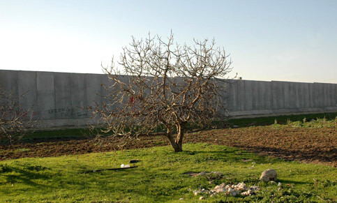
View of the separation wall running through Palestinian lands in the West Bank city of Qalqilia, 26 January 2007. (Khaleel Reash/MaanImages)
In 2002 Israel began construction of the so-called separation wall. By the end of July, the first two segments of the wall were completed, comprising a northern section running from Salem to Elkana, 10km south of Qalqiliyah (128 km length), and the “Jerusalem Envelope” between Ramallah and Bethlehem (22 km). A second phase of work was commissioned in January 2003, extending the northern section as far as Tayasir. A of July 2006, 362 km length were completed and another 88 km under construction. Another 253 km are planned, mainly deep fingers into the West Bank, de facto annexing settlement blocks E and S of Jerusalem and E and SE of Qalqiliyah.
The barrier itself consists of a strip of land between 35 and 50 m wide. The edges are defined by concertinas of barbed wire; within lie a series of ditches and observation strips, with patrol roads between them. At the centre stands “the wall” itself, which can reach up to eight metres high. At different points this is either a real wall, or an electronically secured fence, with contact sensors which can be set off by any movement, from minor vibrations to attempts to cut the wire. Additional observation techniques are also being deployed, including cameras, night-vision devices and radar. The overall length of the wall as currently planned is around 700 km, and a per-kilometre construction cost of around 2 million Euros (11 mil NIS/km, Ha’aretz, 9 May 2003, 21 December 2006 [1]). Since there are almost no Palestinian wells in the southern West Bank, this article will concentrate in the northern section, which is already largely completed.
Walling off the West Bank
The first section of the wall completed was the northern section between Salem and Elkana. Here the wall runs parallel to the border separating the West Bank and Israel, where the foothills of the major West Bank anticline give way to the Western Coastal Plain. More than 15 Palestinian villages have been cut off from the rest of the West Bank by the first stage of construction, and over 30 villages, together with the cities of Tulkarem and Qalqiliyah, have seen significant tracts of land expropriated.
The area of land that lies along the wall is not just any land. Along with Jericho in the Jordan Valley, it forms the heartland of irrigated agriculture in the West Bank. Thirty-seven percent of the area’s agricultural produce comes from the districts of Jenin, Tulkarem and Qalqiliyah. Irrigation is the crucial limiting factor for agriculture in this region. In the year 2000, rain-fed land yielded only 319 tons per square km, where irrigated land produced 6,960 tons, for an economic yield of $430,000 per square km.
Following the Israeli occupation in 1967, and in the absence of any significant Palestinian industrial sector, a peculiar form of structural dependence emerged, as Palestinian labourers migrated to work inside Israel. This movement was heavily encouraged by Israel at the time. The workers concerned found employment mainly in the construction and agriculture sectors.
However, after the first Gulf War in 1991, a permit system was introduced for Palestinians who wanted to work in Israel, and this process of selective closure was intensified following the Oslo agreements in 1993. Soon, it was only the lucky few who were able to get permission to cross the Green Line in search of work, and the number of Palestinians employed in Israel sank to a fraction of its former level. As a result, Palestinians from the border area were faced with two alternatives: returning to work on their own land, or long-term unemployment. Unemployment in these areas is currently running as high as 77.3 percent. Although these are the best lands in the West Bank, the percentage of the labour force which can actually find work in agriculture is surprisingly small, for only six percent of the available land is presently under irrigation. As a result, the agricultural sector can only absorb 11 percent of the active population, whereas over the West Bank as a whole it employs on average 43 percent. The only way these figures will change for the better is if more water is made available for irrigation.
In hydrological terms, this section of the wall is located within the boundaries of the Western Mountain Aquifer (or Western Aquifer). The recharge area for this ground water basin extends over a large area of the West Bank uplands. The pumping area, however, is confined to a narrow strip of land running parallel to the Green Line itself. Due to the natural groundwater flow conditions, only this narrow strip, which is currently inside the West Bank, has any significant potential for raising the level of well abstractions from the aquifer in future.
As Figure 1 shows, the Western Aquifer can be divided into three zones, according to production conditions. The Western Aquifer in turn can be divided into two sub-components — a lower and an upper aquifer. In the eastern zone, only the lower aquifer can be pumped, and this aquifer in any case is only partially saturated at this point, while the upper aquifer here is entirely dry. This zone is therefore defined as having “bad” production conditions. Next to it lies a zone of intermediate quality, which is approximately 5 km wide, and runs directly along the border. Here, both aquifers can be used, although the upper aquifer is still not fully saturated here. It is only to the west of this area, in the zone marked as “good” on the map, that high pumping rates are possible and it is possible for wells to draw on both aquifers, which are now fully saturated and marked by shallow water levels.
To put this in context, we should remember that the Western Aquifer is the single most important groundwater resource in the whole of Israel and Palestine. Current pumping rates are around 360 million cubic metres a year. In dry years, the pumping rate can rise as high as 572 millions cubic metres. As a result, this aquifer alone yields more water than do the two other groundwater basins originating in the West Bank put together. In addition, the Eastern and the North-Eastern Basins exhibit demonstrably less favourable drilling and pumping conditions. The Western Aquifer, however, is more or less perfect: it combines shallow water levels with high pumping rates. As a result, this aquifer has been heavily developed within Israel, mainly during the first decades of the state (the ’50s and ’60s). In the West Bank, on the other hand, since 1967 the Israeli occupation has more or less completely forbidden any drilling activity by Palestinians. During the period between 1967 and 1990, only 23 wells were drilled by Palestinians in the whole of the West Bank: 20 of these were exclusively for drinking water purposes, and were often under the indirect control of the occupying forces (aka. the West Bank Water Department). As mentioned above, while at Oslo Israel did concede a certain number of new drilling sites to the Palestinians in the Eastern and North-Eastern Aquifer Basins, it refused point blank to countenance any new sites in the Western Aquifer. As a result, all the wells which the Palestinians rely on today in this basin date back to Jordanian times. As a result, use of the Western Aquifer resource is now divided in a particularly unequal way: while in Israel there are approximately 500 strongly flowing deep wells, the Palestinians must make do with just 159 old wells, most of which were designed for irrigation purposes, and which are both less deep and less productive than their Israeli counterparts.
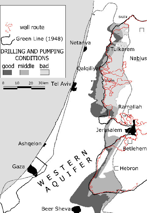
Figure 1
Conflicting interests
Many of the Israeli wells in the Western Aquifer are connected to the Israeli National Water Carrier. As a result, the water they produce is highly mobile and is available for use almost anywhere throughout the whole of Israel. By contrast, many of the Palestinian villages which sit on top of the aquifer have little or no independent water supply of their own, even though there is water directly under their feet. As a result, they too are obliged to buy from Mekorot (the Israeli National Water Company), even though Mekorot does not grant them equal access, whether in terms of quantities, services or pricing. If the Palestinian inhabitants are to develop this region economically and socially in the future, they will have to be able to draw more heavily on its own ground water resources. This explains why this basin has been the most intensely disputed resource in every round of water negotiations between Israel and Palestine.
Water use: some basic figures
Israel uses approximately two billion cubic metres (2000 million cubic metres) of water a year for drinking, agricultural, commercial and industrial purposes. Depending upon annual rainfall and groundwater yields, around 1,100 - 1,200 cubic metres of this amount will be drawn from wells. Of the rest, most originates as surface water, predominantly from Lake Tiberias (400 - 500 million cubic metres/year).
Of the many groundwater basins that are exploited on an intensive basis, the Western Aquifer and the Israeli Coastal Aquifer have the highest recharge rates, receiving an estimated 360 million cubic metres and 370 million cubic metres a year, respectively. The two other West Bank Aquifers together recharge at a rate of approximately 310 million cubic metres each year. Well extraction runs at approximately 50 percent of the recharge rate.
Taking wells and springs together, the Palestinians in the West Bank control around 138 million cubic metres/year (= 20 percent of West Bank groundwater resources), while the Israelis take approximately 562 million cubic metres (= 80 percent). The 2.3 million Palestinians living in the West Bank thus control 138 million cubic metres, while the 1.2 million inhabitants of Gaza use approximately 100 million cubic metres per year. Overall, these 238 million cubic metres give the 3.5 million Palestinians living in the territories only 11 percent of the total water resources of historic Palestine, while the 6.7 million inhabitants of Israel use a total of 2000 million cubic metres, or 89 percent.
Nowhere is this huge imbalance in distribution so grotesquely unfair as in the Western Aquifer, where Israel takes 93 percent of the available water supply. The Palestinians are left with only seven percent of the total yield (25.67 million cubic metres per year, extracted from 159 wells). Palestinian well production is concentrated in the area around the northern section of the wall, and especially around Tulkarem and Qalqiliyah, where an average of 22.19 million m3 is drawn each year from 141 wells (see Figure 2).
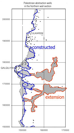
Figure 2
If the Palestinians are to succeed in obtaining fair access to shared water resources through negotiations, they will not only need to be technically well prepared. They will also need to make sure that the true nature of the separation wall, and what it represents in terms of water access, is internationally acknowledged, so that pressure can be brought to bear on Israel — most likely, by the mediating powers, who will certainly play a central role in any future resolution of the situation, whether or not the “road map” is finally implemented. It is therefore vital to begin the fight for public opinion today, even though it may be some time yet before serious negotiations are restarted.
The dispute over the Western Aquifer will become even more vital should Israel refuse to take at least part of the responsibility for supplying water to Gaza. Water use in Gaza has long passed the critical threshold: drastic over-pumping has already caused catastrophic effects, harming both the economy and the ecology of the area, damaging the health of the Gazan population and undermining their basic water supply. Should future negotiations force the Palestinians to supply Gaza with water from the West Bank, then the only possible resource which could be used for this purpose will be the Western Aquifer. For it would make absolutely no sense to pump water from the eastern side of the West Bank, near the Dead Sea, more than 1,000 metres up over the Hebron Mountains, spending billions of dollars on pipelines in the process, when the natural flow conditions of the Western Basin bring the water literally to the front door of Gaza!
For a long time, the Palestinians have been demanding more water, both to drink and to underpin their economic development. Palestine is a long way from being an industrial nation, and there will inevitably be a considerable transition period during which it will have to rely on agriculture. This is especially true for those areas which are close to the Green Line, and where the Israeli closure has brought massive unemployment in its wake. If agricultural development is to happen, water will have to play a key role. This means that when we analyse the effects of the wall, we must not simply focus on the loss of existing land and water resources, we must also be aware of the future development potential that is disappearing with them.


