UN Office for the Coordination of Humanitarian Affairs 8 July 2004

Israel’s Apartheid Wall separating Kalandia, Ramallah and nearby villages from ar-Ram, Beit Hanina and other Jerusalem neighbourhoods (Arjan El Fassed)
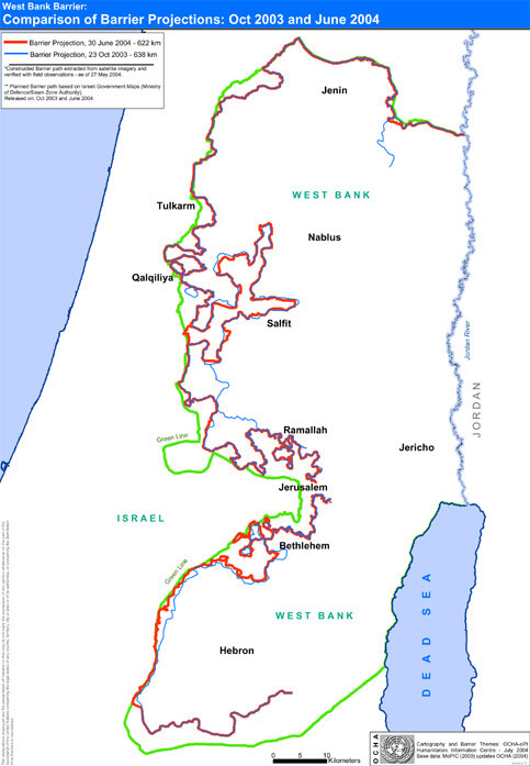
On 30 June 2004, the Government of Israel revised the route of the West Bank Barrier and published a map on its seam zone website. The previous map was released on 23 October 2003. In June 2002, the Government of Israel began construction of the Barrier following several suicide bombings and attacks by Palestinian militants on Israeli citizens. It maintains that the Barrier is a temporary structure to physically separate the West Bank from Israel to prevent such attacks on Israeli citizens. Once completed, the Barrier will be 622 km long.
Approximately 185 km of the Barrier has already been constructed. This section consists of a combination of ditches, trenches, roads, razor wire, electronic fences and concrete walls. The Head of the Knesset Economics Committee estimates that the Barrier will cost $3.4 billion. While part of the Barrier lies on the Green Line, most of the revised route still passes through the West Bank. This report analyses the revised route and its humanitarian impact in these areas.
Analysis of Humanitarian Impact
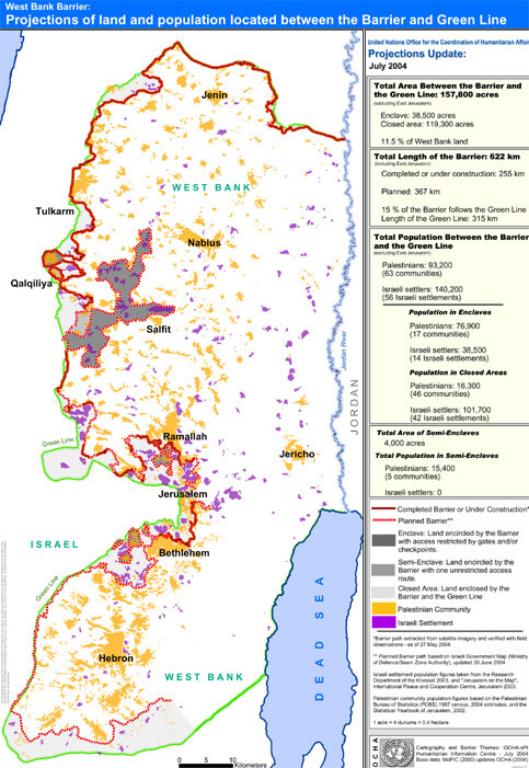
Approximately 157,800 acres2 - or about 11.5 percent - of West Bank land (excluding East Jerusalem) will lie between the Barrier and the Green Line, according to the revised route. (See map attached). This will include 38,500 acres enclosed in a series of enclaves and 119,300 acres in closed areas between the Green Line and the Barrier, excluding East Jerusalem. An additional 4,000 acres are already located in two semi-enclaves, where land is encircled by the Barrier but access via one route is unrestricted.
Palestinian population affected
This land, some of the most fertile in the West Bank, is currently the home for more than 93,200 Palestinians living in 63 villages and towns, excluding the communities in east Jerusalem. 1 All effort has been made to ensure that the figures are as accurate as possible. They are taken from an analysis of the map published on the IDF website. Minor changes may occur once a higher resolution image is obtained. 2 1 acre = 4 dunums = 0.4 hectares.
Of these people, 16,300 will live in closed areas - areas between the Barrier and the Green Line. Another 76,900 will live in enclaves - totally surrounded by the Barrier. In the semienclaves, an additional 15,400 Palestinians live in areas encircled by the Barrier, but they can enter and exit these areas via one route. The Barrier will also affect those people living east of it who may need to cross it to get to their farms, jobs and services. More than 370,000 Palestinians, for example, live within a one kilometre strip of the Barrier (excluding East Jerusalem). Many of these people and many others living further to the east, will be directly harmed by the Barrier.
Barrier length
Stretching a total of 622 kilometres (including East Jerusalem), the revised Barrier route will run from Jenin in the northern West Bank to the southern-most tip of Hebron in the south. Because of its meandering path into the West Bank, the Barrier’s length is approximately twice the length of the 1949 Armistice Line, known as the Green Line.
Departure from the Green Line
Only 15% of the Barrier’s length runs along the Green Line. For the rest, the Barrier’s planned path cuts into the West Bank - up to 22 km where it is planned to envelope the Israeli settlement of Ariel.
Enclaves and semi-enclaves created
The Barrier not only runs inside the Green Line but folds in on itself to create 11 separate enclaves - areas where people are totally surrounded by the Barrier. An additional two semienclaves - Habla and Az Zawiya - with a total population of 15,400 are also totally surrounded by the Barrier. However, movement in and out of these areas, is currently unrestricted along one route.
Access to West Bank jobs and services
People who live in either enclaves or closed areas have been required to pass through gates in the Barrier to reach markets, schools, hospitals and maintain family connections in the remaining areas of the West Bank. Although Israel introduced some changes to the operation of the gates, access for Palestinians in these areas is restricted. UN staff have observed 53 gates in the constructed Barrier. Of these 15 are accessible to Palestinians with the correct permit. Six further gates have official IDF opening hours, but in practice are rarely used by residents. 3 As yet, Israeli Government has not released publicly available information on what access gates will be made available through the projected path of the Barrier.
Israeli settler population affected
Also included in the area between the Barrier and the Green Line will be 56 Israeli settlements containing approximately 140,200 Israeli settlers - an estimated 62 percent of the West Bank settlement population. The majority of the Israeli settlers will live within the same zone of the Barrier as the Palestinians for whom the Barrier was designed to separate.
Palestinians require permits to continue residing in closed areas
Given the latest Israeli policy on permits, Palestinians residing in closed areas between the Barrier and the Green Line face an uncertain future in terms of their personal status and their lands’ status. On 7 October 2003, the Israeli Defence Forces issued a number of military orders closing land areas located between the Barrier and the Green Line in the Jenin, Qalqilya and Tulkarm districts. The current orders require approximately 5,000 residents in these closed areas to apply for permits to remain living in their homes. Private vehicles should also be registered accordingly. These permits are valid for up to six months and in principle are valid for only one gate. Use of other gates is also militarily regulated and allowed only in emergency cases. The Barrier will further restrict farmers living outside this ‘closed zone’ from getting to their land within it. Medical staff, business people and international humanitarian organizations also have to apply for special permits. According to the military orders, Israeli citizens, Israeli permanent residents and those eligible to immigrate to Israel in accordance with the Law of Return, are exempted from these requirements. If the military orders that restrict entry into the closed areas between the Green Line and the Barrier are applied to the new parts of the Barrier, then many thousands of Palestinians are likely to face difficulty continuing to live in their homes or access land.
Humanitarian consequences
As yet no publicly available studies have been conducted by the Israeli Government to measure the Barrier’s impact on Palestinian lives. However, where the Barrier has been constructed, Palestinians have already faced economic hardship from not being able to reach their land to harvest crops, graze animals or earn a living on a daily basis. Residents have also been cut off from schools, universities and specialized medical care by the constructed Barrier. The damage caused by the destruction of land and property for the Barrier’s construction is irreversible in the medium term and undermines Palestinians’ ability to recover should a political situation allow it. The Barrier also fragments communities and isolates residents from social support networks. Even where the Barrier route does not encircle an area as an enclave, its presence may still impact a community. For example, the Barrier route surrounds on three sides approximately 43,900 Palestinians residing in communities between At-Tira and Beit Sira northwest of Jerusalem. Access for these communities through the fourth side to the north is blocked by Highway 443 - a four-lane highway on which Palestinians are not allowed to travel unless they hold a specific permit.
Map: UN OCHA
Map: UN OCHA
Related Links