The Electronic Intifada 6 May 2003
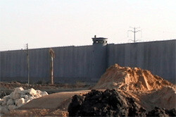
Israel’s apartheid wall as seen from Qalqilya (AEF)
The terrible monster coming towards me was not more than five meters away and continued to move as if I weren’t there. The giant bulldozer pushed a great heap of dirt and boulders before it. The driver, two meters above me, seemed a part of the machine. It was clear that nothing would stop him. I jumped aside at the last moment.
Some weeks ago, in a similar situation, the American peace activist Rachel Corrie expected the driver to stop. He did not, and she was crushed to death.
I did not come on this occasion to demonstrate (we shall do this today) but to look around. In the olive grove, a few meters from the tents that were set up by the villagers of Mas’ha, together with Israeli and international peace activists, three monsters were preparing the ground for the “Separation Wall”. They raised clouds of dust and a deafening roar, so that we could hardly converse. They work every day, even on Passover, 12 hours a day, without a break.
The whole Israeli public supports the Separation Wall. It has no idea what it is supporting. One has to come to the place in order to understand all the implications of the project.
First of all, it has to be said unequivocally: this wall has nothing to do with security.
It is being sold to the Israeli public as a “security fence”. The army calls it an “obstacle”. The public, which of course yearns for security, is buying the goods eagerly. At long last something is being done!
And indeed, the idea looks quite simple. Even the most unsophisticated person can grasp it. It seems almost self-evident: a Palestinian who wants to blow himself up in Israel has first of all to cross the pre-1967 border, the so-called Green Line. If a wall or fence is built along the Green Line, the terrorists will not be able to come. No more attacks, no more suicide bombers.
But logic says that if this had indeed been a security wall, it would have been built directly along the Green Line. All Israelis (except the settlers) would be on one side of it (the western one) and all the Palestinians on the other. The line should be as straight and as short as possible, because it will need inspecting, patrolling and defending. The shorter it is, the easier and cheaper it will be to defend it. That is the logic of security.
But in reality, except for short sections, the wall is not being built on the Green Line, nor in a straight line. On the contrary, it meanders like a river, twisting and turning, approaching the Green Line and receding from it.
Not by accident. The bed of a river is dictated by nature. The water has to obey gravity. But the design of the wall has no connection with nature. The bulldozers are quite indifferent to nature, they cut through it remorselessly. What then determines this design?
Standing near it, the answer is clearly visible. The sole consideration that dictates its path is the settlements. The wall twists like a snake according to a simple principle: most of the settlements must remain on the western side of the wall, i.e. eventually to be absorbed into Israel.
Standing on a hill which will be crossed by the wall, I saw down below, on the western side, Elkana, a large settlement. On the eastern side, only a few dozen meters away, there is the Palestinian village of Mas’ha. The village itself stands on the eastern side, but almost all its lands lie on the western side. The wall will cut the village off from 98% of its lands — olive groves and fields that stretch up to the Green Line, some seven km away, near Kafr Kassem.
Mas’ha is a big village n like its neighbor, Bidia, where thousands of Israelis used to come every Saturday for shopping. Mas’ha, too, was once a blooming village. It has a big industrial zone, now completely deserted.
One can reach the village only on foot, climbing steep tracks. At the beginning of the intifada, the Israeli army blocked the main road with two piles of earth and rocks. No vehicle can pass.
“First they came to destroy our livelihood,” the village chief, Anwar Amar, says bitterly. “Now they come again to take away our land.”
Indeed, the foul smell of “transfer” hovers over the wall. Its location leaves whole Palestinian villages on the western side n trapped between the wall and the Green Line. The inhabitants will not be able to move, to find a livelihood, to breathe. Other villages, like Mas’ha, will remain on the eastern side of the wall, but their land, on which their livelihood depends, will be on the western side.
There are places, like the town of Kalkiliya, which will be almost completely surrounded by a loop of the wall, leaving only a small opening to the West Bank. One of the purposes of the wall is, without a doubt, to make the lives of the inhabitants hell, in order to convince them by and by to go away. It is a kind of “creeping transfer”.
Like the terrifying bulldozer pushing before it rocks and lumps of earth, so the occupation pushes before it the Palestinian population n always eastwards, always out.
Historians can see this as a continuous process that started 120 years ago and has not stopped for a moment. It began with the eviction of the Felaheen from land that was purchased from absentee landowners and continued with the Nakba of 1948; the massive land expropriations from Arabs in Israel after that war; the expulsions during the 1967 war; the creeping eviction by means of settlements and bypass roads throughout the years of the occupation; and now the expulsion caused by the wall. The Hebrew bulldozer rolls in front. Not by chance, Arial Sharon’s nickname is “the bulldozer”.
The wall of Mas’ha and Kalkiliya, which continues to the Gilboa mountains, is not the only one. To the east of it, a second wall is already being planned. It will embrace the Ariel and Kadumim settlements and penetrate 20 km into Palestinian territory, almost reaching the central axis of the West Bank, the Ramallah-Nablus road.
However, even this is not the whole picture. Sharon is now planning the “Eastern Wall” that will cut off the West Bank from the Jordan valley. When it is finished, the whole West Bank will become an island surrounded by Israeli territory, cut off on all sides. Also, the southern West Bank (Hebron and Betlehem) will be cut off from the northern West Bank (Ramallah, Nablus, Jenin), which will also be divided into several enclaves.
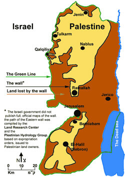
Gush Shalom map showing area in orange to be lost from West Bank by the proposed wall (click for enlargement).
This is exactly what Sharon has in mind when he speaks about a “Palestinian state”. It will consist of several enclaves, each one surrounded by Israeli territory, without an external border with Jordan or Egypt. Sharon has been working on this plan for decades, setting up dozens of settlements according to its map.
The wall will serve this purpose. It has nothing to do with security, it certainly will not bring peace. It will only bring more hatred and bloodshed. The very idea that an obstacle of cement or wire could stop the hatred is ludicrous.
The work continues now from early morning to late evening. Sharon talks about the Road Map while creating “facts on the ground”.
But this wall also has a deeper meaning. It is no accident that it is so hugely popular in Israel, from Sharon to Mitzna and Beilin. It satisfies an inner need.
In his book “Der Judenstaat”, the founding document of Zionism, Theodor Herzl wrote the following sentences: “For Europe, we shall be there (in Palestine) a section of the wall against Asia. We shall do pioneer service for culture against barbarism.”
This idea, that we are the outpost of Europe and need a high wall between us and Asiatic barbarism n i. e. the Arabs n is thus imbedded in the original vision. Perhaps it has even deeper roots. When the Jews began to congregate in Ghettos, before this was decreed from the outside, they surrounded themselves with a wall, in order to separate themselves from a hostile environment. Wall and separation, as guarantees of security, are deeply imprinted in the Jewish collective unconscious.
But we, the new Hebrew society in this country, did not want to be a new Jewish ghetto. We did not seek separation, but the opposite n to be open to the region. Not “a villa in the jungle”, as Ehud Barak put it, not a European outpost against Asiatic barbarism, as seen by Herzl, but an open society that lives in peace and prospers in partnership with the nations of this region.
This evil wall is not only an instrument for dispossessing the Palestinians, not only an instrument of terrorism masquerading as a defense against terrorism, not only an instrument of the settlers disguised as a security measure. It is, most of all, an obstacle facing Israel, a wall blocking our way to a future of peace, security and prosperity.
Related Links
Uri Avnery is an Israeli journalist, writer, and peace activist who was one of the founders of Gush Shalom.


